Two Rules Joined in the Form of a Cross: Riccioli's Twelve Books of Reformed Geography and Hydrography
Giovanni Battista Riccioli, the Jesuit astronomer of Bologna, spent the years after his vast Almagestum Novum building something stranger: a folio called Geographiae et hydrographiae reformatae libri duodecim (1661), which set out to correct the whole inherited science of the earth and its seas by measurement, tabulation, and the collated testimony of working pilots. Across twelve books it fixes the length of a foot, computes the height of Mount Athos from a shadow reported by Pliny, prints a specimen sea-journal for 1 April 1645, Latinizes the toponymy of New England and New Amsterdam, and closes by guessing how many people were then alive on earth. What holds it together is a habit rarely found in encyclopedias: a willingness to say, in print and by name, exactly where the numbers stop being trustworthy.
ExLatinis
September 14, 2026

Contents
Giovanni Battista Riccioli, the Jesuit astronomer of Bologna, spent the years after his vast Almagestum Novum building something stranger: a folio called Geographiae et hydrographiae reformatae libri duodecim (1661), which set out to correct the whole inherited science of the earth and its seas by measurement, tabulation, and the collated testimony of working pilots. Across twelve books it fixes the length of a foot, computes the height of Mount Athos from a shadow reported by Pliny, prints a specimen sea-journal for 1 April 1645, Latinizes the toponymy of New England and New Amsterdam, and closes by guessing how many people were then alive on earth. What holds it together is a habit rarely found in encyclopedias: a willingness to say, in print and by name, exactly where the numbers stop being trustworthy.
Giovanni Battista Riccioli (1598–1671), a Jesuit of Ferrara who spent his mature career in the Society's Bolognese college and is best known to historians of astronomy for the vast Almagestum Novum of 1651, published at Bologna in 1661 a folio of comparable ambition on an entirely different subject: Geographiae et hydrographiae reformatae libri duodecim, "Twelve Books of Reformed Geography and Hydrography." It is an encyclopedic Latin treatise, printed in two columns and illustrated, running to some six hundred and forty pages in its first impression and reappearing in 1672 in a revised and enlarged issue. Its twelve books move from the elements of mathematical geography through the measurement of terrestrial intervals, map construction, coordinates, and surveying, into a long hydrographic book on seas, winds, tides, ports, ships, and navigation, then into an alphabetical repertory of place-names in Latin and the vernaculars, and finally into a synoptic book expounding an instrument of Riccioli's own devising, the Crux Geographica, before closing with an appendix estimating the number of human beings then alive on the earth.
The problem the work sets itself is stated in its title and pursued on nearly every page: the geography and hydrography inherited from ancient authority and from speculative natural philosophy does not correspond to what is actually known of the globe, and it cannot be relied upon by those whose lives depend on sailing it. Riccioli's characteristic response is twofold, and it is the spine of the whole. First he displaces speculation with collated testimony — charts, relations of voyages, catalogues of ports, the daily notations of pilots and shipmasters — treating such records as an evidentiary genre with standing of their own, and holding that the philosophers' many recent volumes on the causes and signs of the winds yield less usable knowledge than what practitioners have observed. Then he regularizes what he has gathered into apparatus: quadrilingual tables of the cardinal and collateral winds, sets of loxodromic problems with their tables, a specimen sea-journal, an alphabetical onomasticon, and the Crux Geographica itself. Scattered report is thus converted into teachable rule. Running alongside both operations is a persistent grading of epistemic status — what holds in rigore Geometrico distinguished from what suffices physicè, demonstration distinguished from conjecture, with open confession where a case remains unresolved.
The stakes of that programme are not confined to geography. Riccioli's hydrographic book enters the most consequential technical controversy of seventeenth-century seafaring, the determination of longitude at sea, and does so in full awareness that the difficulty had been made the object of royal and mercantile inducements; it reports the failure of every timekeeping device then available to a ship's company and the partial remedies offered by the sandglass and by the instruments of Georges Fournier. Its onomastic book confronts the instability of place identity across Latin, vernacular, antiquarian, missionary, and maritime usage at the moment when European navigation and mission were multiplying names faster than any single scheme could absorb them. Its demographic appendix has been identified by Martin Korenjak as the first systematic attempt presently known to estimate the population of the entire world, placing Riccioli in the prehistory of political arithmetic while keeping visible the distance between his regional conjectures and the English discourse of Graunt and Petty. And the whole is a Jesuit mathematical production, licensed and approved within the Society and issued Superiorum Permissu, ac Privilegio, which makes it evidence for how empirical compilation could be authorized as useful to the commonwealth rather than merely tolerated.
What a first-time reader is likeliest to find memorable are the particulars. There is a catalogue of harbours and arsenals running alphabetically across Europe, Africa, Asia, and the Americas, declared to be raw material for the rectification of geographical and hydrographical charts. There is a sea-journal presented as a genre with a definition, a specimen entry dated 1 April 1645 aboard the ship S. Raphael, and a sharp complaint against those pilots and merchants who suppress such records for private advantage. There is an antiquarian excursus that argues Noah's Ark was not, properly speaking, a ship, and that moves from the oar-bank controversy over ancient triremes to bilingual nomenclators of the canoa, almadia, caracora, piragua, champan, and ionco. There is a gazetteer that Latinizes the newest colonial toponymy — Anglia noua, Amsterodamum nouum — and defends its own procedure with the maxim that it is better for grammarians to fault the author than for ordinary people not to understand. And there is the Crux Geographica, two crossed rules and two curved plates laid on a map with parallel meridians, which Riccioli offers as a pair of geographical wings by which a mind shut in one corner of the earth may fly over the whole of it.
A single throughline binds the work's vocabulary, its making, and its internal argument. Reformata in Riccioli's usage is a methodological rather than a confessional word: it names the emendation and ordering of an inherited discipline by revised measurement, tabulation, nomenclature, and the comparison of authorities. That reforming ambition is what the Jesuit licence authorizes as serviceable to the public good; it is what dictates the architecture of twelve books ascending from isagogic definitions to a synoptic instrument; and it is what governs the tone of the individual chapters, which are willing to tabulate, willing to correct, and equally willing to stop and say that the matter is not clear. Much about the volume remains open — the full history of its issues, the identity of its engravers, the extent of any censorial intervention, and its later reception among hydrographers are all underdetermined by the evidence so far recovered, and the dedicated scholarship on the geography remains thin beside the literature on Riccioli's astronomy.
Read the full text and English translation on Leo
This text was transcribed and translated as part of the ExLatinis project, an effort by Leo to make free English translations of every text published in Latin in early modern Europe (1450–1750) available online. The complete transcription and English translation of this work can be read free of charge:
→ Read the original Latin text and full English translation on Leo
You can save a copy of this document into your Leo account to run deep text searches, conduct further analysis, or cross-reference it with your own research.
Naming the Work: Riccioli's Reformata and the Vocabulary of Corrected Geography
Editorial English title: "Twelve Books of Reformed Geography and Hydrography," an English rendering supplied for scholarly convenience of Giovanni Battista Riccioli's Geographiae et hydrographiae reformatae libri duodecim. The adjective reformatae is not a confessional label in the narrow sense. In Riccioli's title it denotes the emendation, ordering, and practical correction of an inherited discipline through revised measurements, tables, instruments, nomenclature, and comparisons among authorities. Its force is methodological: geography and hydrography are to be made more exact, serviceable, and internally coherent without abandoning the learned traditions from which they derive.
That reform is calibrated rather than absolute, and the text supplies its own criterion. Discussing the successive changes of course by which a vessel may approximate a great circle, Riccioli observes that the more frequent and subtle the variation, the more closely the ship is held physically in the same or nearly the same great circle, that is, without sensible difference, for in geometrical rigour a slight continuous inclination would have to be made in each meridian the ship runs into, Sed quo crebrior, ac subtilior sit variatio, eo arctus retinctur nauis in eodem, vel prope eundum circulum maximum Physicè, seu absq[ue] sensibili differentia, nam in rigore Geometrico, in singulis Meridianis, in quos nauis incurrit, facienda esset aliquantilla continuè inclinatio. The contrast between rigor Geometricus and what holds physicè is the load-bearing distinction of the whole work: it licenses the tabulated approximation without disguising it as demonstration, and it recurs wherever the text moves between proof and practice.
The work's onomasticus is likewise more than a simple list of names. As a genre designation it signals a systematic treatment of places through the relation between Latin forms, vernacular variants, regional usage, and the geographical objects to which those names refer. Riccioli's onomastic practice therefore belongs simultaneously to geography, lexicography, antiquarian learning, and the administrative ordering of space. It treats unstable names as evidence requiring comparison rather than as transparent labels, and it says so at the outset of the repertory: let no one wonder if he here and there meets a differing nomenclature of the same place in the onomasticon, for this was produced by the remoteness of places and times, or the diversity of idioms and dialects, or the uncertainty of conjecture, Nemo porto miretur, si diuersam eumdem loci nomenclaturam in nostro Onomastico parlim offenderit: Hanc enim peperit longinquotas locorum, ac temporum, aut diuersitas Idiomatum. vel Dialectorum; aut incertitudo concreturæ. Divergence is here diagnosed rather than suppressed, and its three causes — distance in space and time, variety of tongues, and the fallibility of inference — are precisely the conditions that make the comparative repertory necessary.
The criterion that governs Riccioli's own Latin coinages follows from the same diagnosis. Against the objection that his forms offend against classical usage he answers that it is better that the grammarians should censure us than that the people should not understand, Melius est vt nos reprehendam Grammatici, quam non intelligant Populi — intelligibility, that is, outranks purity, because the repertory exists to be used. The principle is visible in the treatment of recent colonial toponymy, where the vernacular forms are registered beside a Latin equivalent supplied for the occasion, as in the entry giving New England or Nouvelle Angleterre, New England, a region of America, Neuu England seu Nouuelle Angleterre, Anglia noua, regio Americæ. Such entries show a Latin nomenclature being extended, deliberately and by convention, to territories the ancient geographers never named.
The same conventionalism governs the technical vocabulary of the winds. Riccioli notes that although winds can blow into as many regions and quarters of the horizon as the horizon itself can be divided into, nevertheless, because excessive distinction breeds confusion and is useless, the ancients distinguished them into four principal ones, Etsi verò Venti in tot regiones, ac plagas horizon-tis flare possunt, in quot diuidi potest idem Horizon; quia tamen distinctio nimia confusionem parit, & inu-tilis est: Veteres distinxerunt eos in quatuor pri-marios. A division of the horizon is thus an instrument of intelligibility, not a discovery about nature, and it may be superseded when practice requires a finer grid: the moderns, Riccioli reports, divided the horizon into thirty-two parts, just as the mariner's compass, Horizontem diuiserunt in triginta duas partes, sicut Pyxidem Nauticam. The pyxis nautica has become the standard against which the learned taxonomy of winds is reset — an exact instance of the work's larger movement from inherited authority to the regularized practice of navigators.
Vernacular maritime vocabulary enters the Latin on the same terms, retained where the practitioners' word is the precise one. The sandglass is introduced under the name given it by the men who use it, which the Italian sailors call the ampolletta or ampolla del Poggio, quod Nautæ Italici vocant Am-polletam vel ampolla del Poggio. Such glosses are not ornament: they mark the point at which the text's authority passes from the library to the deck.
The treatment of the longitude problem gives technical force to the notion of the longitude point, or punctum longitudinis. Longitude appears not merely as a geometrical coordinate but as an unresolved practical point whose determination depends upon distances, winds, currents, magnetic variation, and the reliability of navigational observation. The problem is consequently connected to royal and mercantile rewards as well as to mathematical demonstration, as the text itself insists in naming it: this is precisely that famous Point of Longitude, for whose discoverer the Catholic Kings and the Dutch company have promised so many thousands of gold pieces, Hoc nimirum est illud Punctum Longitudinis, cuius inuentori tot millia aureorum polliciti sunt Reges Catholici, & Hollandensium Societas. Riccioli's reforming vocabulary joins learned exactness to practical sufficiency: the work seeks a geography that can order the world, instruct the navigator, and distinguish demonstrable measure from a carefully marked conjecture.
Definitional boundary-work of a more antiquarian kind belongs to the same philological programme. Reviewing the claim that the first of all ships was Noah's Ark, Riccioli refuses the identification on the ground that the thing lacked the defining apparatus of a ship: although Polydore Vergil, Giraldi and Scheffer recognize Noah's Ark as the first of ships, in truth it was not a ship, nor was it navigated by human art, being without oars, rudder or sails, God being its architect and governor, licet Polydorus Virgil. lib. de inuentoribus rer. cap. 15. Gyraldus, & Schefferus lib. 1. cap. 2. primam nauium agnoscant Arcam Noe, neuera tamen illa non fuit nauis, nec per eam arte humana nauigatum, vt pote sine remis, temone, ac velis, Deo tanto Architecto, & Gubernatore illius. The move is characteristic: a term of art is fixed by the human practice and equipment that constitute it, and the weight of cited authority is set aside when the definition will not bear it.
What the Twelve Books Contain: A Summary of Riccioli's Bologna Folio of 1661
Giovanni Battista Riccioli, S.J. (1598–1671) authored Geographiae et hydrographiae reformatae libri duodecim, an encyclopedic Latin treatise in twelve books first printed at Bologna in 1661 by the heirs of Vittorio Benazzi. The catalogue evidence describes a folio volume of approximately 640 pages, printed in two columns and illustrated. A substantially revised and enlarged issue appeared in 1672 under the imprint of Giovanni La Noù; a digitized copy of that issue is recorded as a 695-page Bavarian State Library exemplar.
The work is not only a geographical compendium. Its architecture incorporates mathematical geography, measurement of terrestrial intervals, map construction, terrestrial and celestial coordinates, hydrography, meteorology, ports and naval institutions, navigation, ship types, a multilingual place-name repertory, the instrument called the Crux Geographica, and a synoptic concluding book. The printed index identifies Book X as Hydrographicus, Book XI as Onomasticus, and Book XII as Synopticus. Nautical and navigational materials therefore belong principally to the hydrographic book's internal sections and chapters rather than constituting separately numbered books. The surviving evidence verifies Books I–VII and IX–XII; the heading of Book VIII has not been recovered and should not be reconstructed conjecturally.
The text is composed in Latin and incorporates vernacular maritime, geographic, and toponymic forms from several languages. Its nautical sections include discussions of winds, ports, naval practice, magnetic variation, longitude, sailing distances, and the keeping of a nautical diary — a genre the text defines with care, a sea-journal, called in Italian portulano, being a brief but almost daily notation of things observed in the course of sailing, not only for the memory of the past sea-voyage but also and chiefly for the instruction and direction of a future one, Diarium Nauticum, quod Italicè dicitur Pertulano, est breuis, sed quotidiama ferè adnotatio eorum, quæ inter nauigandum obseruata sunt, non ad memoriam tantum præteriti itineris maritimi, sed etiam, & præcipue ad instructionem directionemque futuri. The forward-looking clause is the point of the definition and of the work's method generally: a record is valued for the instruction it yields, not merely for what it commemorates.
The same logic governs the treatment of harbours, where the discursive survey of European, African, Asian, and American ports gives way to an alphabetical catalogue of ports and arsenals compiled from general rather than local charts, a plan the text announces in advance, promising that concerning the other ports and naval stations, it will be spoken of in the catalogue of those which the author will at length append from the more universal nautical and geographical charts, not from particular ones, De alijs autem portubus, ac Naualibus dicetur in Ca-talogo eorum, quæ ex vniuersalioribus Chartis Nauti-cis, ac Geographicis, non ex particularibus hic tandem adiungam. The concluding apparatus includes the Crux Geographica and an appendix on the number of inhabitants of the earth. No complete translation into a modern language was verified in the accessible catalogues and scholarship; a definitive claim that no partial translation exists would require a separate translation-history investigation.
Reading Riccioli Beyond the Almagestum Novum: Jesuit Science, Public Utility, and the Historiography
Riccioli's Geographiae et hydrographiae reformatae matters because it extends the history of his scientific work beyond the astronomy for which he is usually known. The book presents geography as a discipline made through the coordination of terrestrial measurement, map practice, nautical observation, linguistic comparison, antiquarian testimony, and institutional authorization. Its twelve-book design shows that early modern geography could be simultaneously mathematical, descriptive, philological, hydrographic, antiquarian, and demographic rather than belonging to a single modern disciplinary category.
Peter Dear's account of Jesuit mathematical science emphasizes the reconstitution of experience through instruments, demonstrations, and ordered procedures of observation. That interpretation is particularly apt for Riccioli's treatment of distances, scales, coordinates, magnetic variation, the nautical diary, and the Crux Geographica. What counts as experience here is specified by genre: alongside charts and catalogues Riccioli names, as sources of knowledge about the winds, the relations of voyages, and the journals of those who sail, & Relationes nauiga-tionum, & Diaria nauigantium. It is specified also by the practitioners' own questions, since what the text undertakes to answer is defined as what sailors and shipmasters seek out in the knowledge of the winds, for their own safety and speed in undertaking voyages, hæc enim, & similia sunt, quæ à Nautis, ac Nauclerij in Ventorum notitia inquirunt ad suam securitatem, & celeritatem in nauiga-tionibus suscipiendis. The work does not simply oppose "theory" to "practice"; it assigns different kinds of authority to geometrical proof, physical sufficiency, pilot testimony, inherited textual learning, and repeated observation.
Sheila J. Rabin's historiographical treatment of early modern Jesuit science is useful for avoiding the older reduction of Jesuit scientific activity to either confessional censorship or passive transmission. Riccioli's licences and approbations instead reveal a regulated institutional setting in which mathematical compilation and empirical inquiry could be authorized as useful to the res publica. That appeal to public utility is not merely a formula of the preliminaries but an argument inside the text, directed against the withholding of navigational records: some, either to sell their labour dear to merchants as though indispensable, others lest their errors be detected by the more skilful, conceal these ephemerides, to the great detriment of the public good, Sed quidam, vel vt suam operam tanquam necessariam Mercatoribus caro venditent, quidam ne ipsorum errores à peritioribus dete pantur, occultant has Ephemeridas magno boni publici detrimento. Publication, on this view, is itself an obligation of the discipline, and the licensing apparatus that permits the volume and the ethic of disclosure it advances belong to the same institutional world.
Riccioli's astronomical reputation remains central to interpretation of his geography. Scholarship on the Almagestum Novum and on his anti-Copernican arguments, including Christopher M. Graney's analysis of Riccioli's arguments concerning terrestrial motion, demonstrates that Riccioli was neither simply an uncritical traditionalist nor an unambiguous precursor of later experimental science. He was an observer, compiler, critic, and evaluator of competing demonstrations. The geographical work deserves a similar treatment. Its importance lies not in a simple opposition between modern science and scholasticism but in the way it ranks authorities and marks the limits of certainty within a Jesuit encyclopedic project — a marking that can be explicit to the point of self-exposure, as when the author writes that he will not fear to confess frankly that it is still not clear to him whether this conjecture of his is true, so that he seems to himself to be tossed in a shipwreck of opinions, from which he cannot emerge by his own effort, Nec tamen verebor ingenue fateri mihi adhuc non liquere, an hac nostra coniellura vera sit, vt mihi in opinionum naufragus versari videar, è quibus per me ipse emergere nequeo. The nautical metaphor of the naufragium opinionum is exactly calibrated to the subject matter, and the admission functions as a methodological signal rather than as rhetorical modesty.
The hydrographic sections engage a wider field of early modern navigation: the determination of longitude, the effects of magnetic variation, the use of rhumbs and parallel distances, the comparison between great-circle geometry and navigational convenience, and the value of pilots' records. The polemical justification for this reordering of authority is stated plainly. Of the winds Riccioli remarks that from the seamen's records these nautical motions and storms become better known than from the meteorologists, who could scarcely know, or barely touched upon, the regions of sky and earth over which those winds are wont to blow or, as if subject and proper to them, to hold sway, à quibus certè melius nautici isti motus, ac tempestates innotescunt, quam à Meteorologicis, qui vix scire potuerunt, aut vertebrant plagas Cœli, atque Terræ, quibus flare, aut velut subditi, & proprij dominari solent. He adds that the natural philosophers do not even agree about the names or divisions of the winds, a matter in which several have displayed greater subtlety of wit than skill from experience, Neque de Nominibus, aut diuisionibus Ventorum Physicis convenit, in quo non-nulli maiorem ingenij subtilitatem, quam experientiæ peritiam ostentarunt, and that no such great fruit can be expected from so many recent volumes, which have been written so confidently, so prolixly and so speciously about the causes and signs of the winds, matters buried so deep in our ignorance, Neque enim tantus fructus expectari potest ex tot vo-luminibus recentioribus, quæ de Ventorum causis, & signis nobis, adeo in profundum insipientiæ nostræ abstrusis, tam confidenter, tamque prolixe, & speciose scripta sunt. The judgement is not scepticism about causal inquiry as such but a verdict about where, for a discipline that must serve navigators, reliable knowledge is presently to be had.
Two further passages show how that verdict is disciplined in turn. The practical procedures rest on a stipulation the author makes explicit rather than concealing: the sea-chart is supposed to be in no way deceptive, and the places on it correctly marked, so that from the ship's point one may name the place where the ship is, supponitur autem Charta Marina esse minimè fallax, & loca in ea esse rite consignata. vt puncto nauis inuenio nominare possis locum vbi est nauis — a supposition acknowledged as such, in a work that elsewhere treats chart error as a live problem. And where geometry and practice diverge, the criterion of usefulness decides: having computed the gain from great-circle sailing on a particular course, Riccioli concludes that the saving of two Italian miles is not such that it is worth the trouble to depart from the common method of navigating, Igitur compendium duum milliarium Italicorum non est tantum vt operæ pretium sit a conumni methodo nauigandi recedere. The longitude problem joined mathematical difficulty to royal and mercantile inducements, while the nautical diary and the appeal to public utility gave the publication of navigational knowledge an ethical and political dimension. The work's treatment of winds, tides, ships, ports, and naval offices also places it within debates involving Fournier, Crescenzio, Dudley, Varen, Morisot, Clavius, Mersenne, and other authorities. The accessible secondary literature is much richer for the general history of navigation and Jesuit science than for Riccioli's hydrography specifically; claims about direct influence on later hydrographers should therefore remain restrained.
The Onomasticus is significant for the history of cartography and toponymy because it treats names as historically layered and linguistically variable. Latinized, vernacular, antiquarian, missionary, and maritime forms coexist in a single geographical apparatus, and the stated causes of their divergence — distance of places and times, diversity of idioms and dialects, uncertainty of conjecture — are the same conditions that make comparison, rather than simple registration, the repertory's method. Such a repertory reveals the labor involved in stabilizing place identity across languages and traditions. The catalogue of ports extending across Europe, Africa, Asia, and the Americas likewise provides evidence for the relationship among cartographic description, commercial navigation, missionary geography, and imperial knowledge, although the political meanings of individual entries require close comparison with their cited authorities.
Martin Korenjak's study of Riccioli's world population estimate identifies the demographic appendix as the first systematic attempt presently known to estimate the population of the entire world. That finding places Riccioli within the prehistory of political arithmetic while preserving the distinctive character of his procedure: regional conjecture, criticism of census evidence, attention to plague and depopulation, and explicit differentiation between probability and demonstration. The appendix closes by insisting on its own epistemic grade — for we, according to the title of the Appendix, attempting a probability by mere conjecture as best we could, have played with numbers, but have not deluded the world, Nos enim iuxta titulum Appendicis ex mera coniecta vtcumq[ue] verisimilitudinem attentando Lusimus en Numeris; sed non illusimus Orbi — a formulation that carries the same distinction between demonstration and marked conjecture that governs the nautical books. Comparison with John Graunt and William Petty is therefore illuminating but should not erase the institutional and intellectual differences between Riccioli's Jesuit geography and English demographic discourse. The geography and hydrography itself remains comparatively neglected beside Riccioli's astronomy. The thinness of dedicated scholarship is an established limitation of the historiography, not a reason to attribute to the work a reception history that has not been documented evidence by evidence.
Printing, Licensing, and the Physical Book: The 1661 and 1672 Issues
The secure bibliographical starting point is the Bologna edition of 1661: Geographiae et hydrographiae reformatae libri duodecim, authored by "Jo. Baptista Ricciolio Ferrariensi," printed at Bologna by the heirs of Vittorio Benazzi. Catalogue descriptions give a folio format, approximately 37–39 cm in height, two-column printing, illustrations, and a main sequence of 640 pages preceded by a varying number of preliminary leaves. One catalogue records "[22], 640 p."; another gives "[18 p.]–640 p."; a further record gives "[20], 640 p." These discrepancies may reflect copy-specific cataloguing, differing descriptions of preliminary matter, or issue variation. They should not be collapsed into a single definitive collation without examination of multiple physical exemplars.
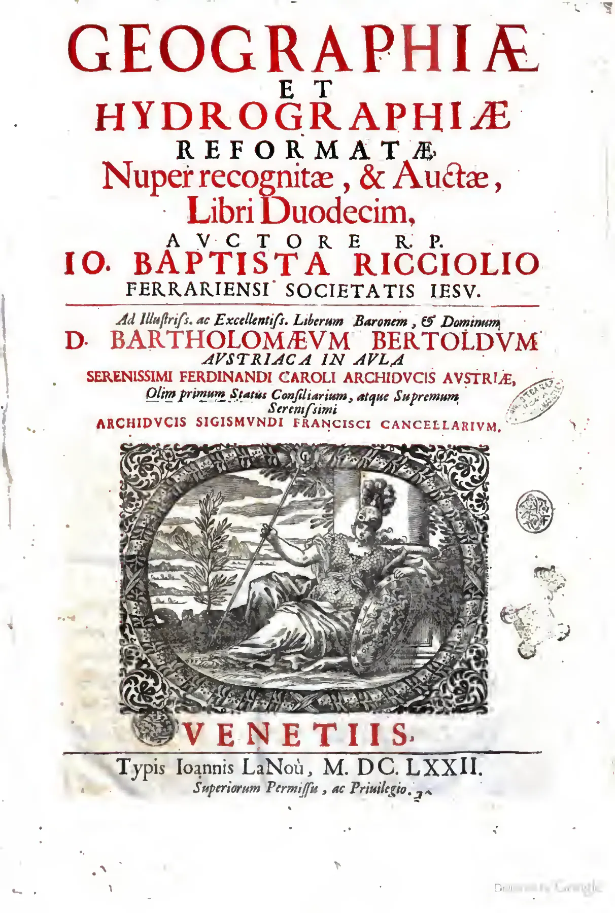
The Venice title page of Riccioli's Geographiae et Hydrographiae Reformatae advertises the 1672 issue as "Nuper recognitæ, & Auctæ" — recently revised and enlarged — distinguishing it from the Bologna impression of 1661. Its imprint for Giovanni La Noù, its dedication to Bartholomäus Bertoldus, and its licensing formula "Superiorum Permissu, ac Privilegio" place the enlarged work at the meeting point of Venetian printing, aristocratic patronage, and authorized Jesuit scholarship. Source ↗.
The 1661 issue is represented in the Biblioteca Nacional de Portugal's digital catalogue and in a digitized copy with shelfmark HG-743-A; the same catalogue exposes public digital surrogates under several persistent links. The Bologna Archiginnasio catalogue independently records the work as a 1661 folio printed in Bologna by "Benacci Vittorio erede." A French catalogue record likewise describes the Bologna impression as 640 pages and approximately 39 × 27 cm. These are verified catalogue records, not merely second-hand bibliographical references.
A later issue or reissue is recorded under the title Geographiae et hydrographiae reformatae, nuper recognitae, & auctae, libri duodecim. Google Books metadata identifies Giovanni La Noù as printer, gives 1672 as the publication year, attributes the original copy to the Bayerische Staatsbibliothek, records digitization on 11 May 2012, and describes a 695-page volume. The accessible metadata does not establish the city, the complete collation, the number of plates, or whether the 1672 issue contains cancellans, reset sheets, or merely an enlarged setting. The frequently repeated attribution of a later Venice issue was not independently confirmed. The evidence supports a 1661 Bologna impression and a distinct 1672 issue or reissue, but not a complete analytical bibliography of all states.
The title-page and preliminary matter attest to Jesuit and ecclesiastical authorization. The volume bears the formula "Superiorum Permissu, ac Privilegio." The printed licence names Jesuit superiors and recognizes Riccioli's geographical work as suitable for printing; a further approbation invokes conformity with Catholic faith and good morals and permits publication. The surviving transcription does not preserve the relevant dates reliably enough to state them with confidence, and no ARSI shelfmark or revisers' report was located. Consequently, the evidence establishes the presence of a licensing and approbation apparatus but does not establish that particular passages on cosmology, tides, or navigation were altered by censorship.
The book's internal organization is unusually important to its material and intellectual identity. The recovered index names Book I Isagogicus, Book II Stadiasmicus, Book III Periegeticus, Book IV Geoditicus, Book V Geometricus, Book VI Altimetricus, Book VII Geoplaticus, Book IX Mecoplaticus, Book X Hydrographicus, Book XI Onomasticus, and Book XII Synopticus. Book X contains material on seas, winds, weather, ports, navigation, ships, and naval offices, followed by numbered sectiones and extensive chapters; within it the alphabetical catalogue of ports and arsenals is offered as working material for the rectification of geographical and hydrographical charts, and its scope is delimited in advance by the author's promise to draw on general rather than particular charts. Book XI treats place names through Latin and vernacular forms and their synonymies, organized as an alphabetical gazetteer running in both directions between Latin and the vernaculars and subdivided by generic elements such as Lago, Mare, Monte, Porto, Regno di, Rio de, and Santo. Book XII presents and explains the Crux Geographica, an instrument composed of intersecting rulers or plates for use upon a map and for relating terrestrial position to solar phenomena. Riccioli's own definition specifies both the components and the conditions of use: he calls the Geographical Cross a certain instrument, composed of two rules joined in the form of a cross and of two plates almost imitating the shape of a sigma, fit to represent on a geographical map ruled with parallel meridians, at any given moment, all the varieties of days, nights and hours occurring at that moment throughout the whole world within the torrid and temperate zones, CRVCEM GEOGRAPHICAM voco Instrumentum quoddam, quod duabus regulis in Crucis formam compactis, & duabus laminis sigmatis figuram fermè imitantibus conflans, aptum est in Mappa Geographica meridianis distincta parallelis, repræsentare quocunque momento dato, quascumq[ue] dicrum, noctium, & horarum varietates toto orbe terrarum intra Torridam, Temperataque Zonas, eo momento contingentes. The zonal restriction is stated as part of the definition, a further instance of the work's habit of publishing the limits of its own devices. The same chapter offers the instrument's rationale in a figure: if anyone should call the arms of this Cross Geographical Wings, by which our mind, though shut up in a single corner of the earth, may yet fly over the whole world, he would not deviate much from the truth, Quare li quis Crucis huius brachia Alas Geographicas, quibus animus noster, vno licet terrarum angulo inclusus, orbem tamen vniuersum peruolitate queat, appellauerit, is non à veritate multum deflexeret. The evidence does not justify inventing the missing Book VIII title.
The nautical apparatus includes discussions of magnetic declination and its variation from place to place, the practical difficulty of determining longitude, sailing distances and tables, and the form of a nautical diary. Its treatment of shipboard timekeeping begins from an inventory of failures: the difficulties which shipmasters suffer in observing time, and by which they are often carried into error, are not few, for the sundials in use among us, or hour-instruments, can neither conveniently stay in the same position when so agitated by motion, nor are they always lit by sun or stars, and so under a cloudy sky they fail the shipmaster, DIfficultates, quas patiuntur Naucleri in obseruatione temporis, & quibus sæpe in errores rapiuntur, non parum abundant. Nam Solaria quæ apud nos vsitata sunt, aut Instrumenta Horaria, nec commode tanto motu agitata possunt sistere in eodem situ, nec semper à Sole, aut Stellis illuminantur, ac proinde cælo nubilo destituunt Nauclerum. The remedies canvassed run from the Italian sandglass to a series of sun-instruments associated with Fournier, of which the last is commended on grounds of both name and generality: the fifth instrument is the Nauicula, which most pleases sailors both for the aptness of its name and for its universality, because it serves at every latitude, Quintum instrumentum est Nauicula, quæ Nautis maximè arridet ob nominis conuenientiam, & ob vni-uersalitatem, quia omnibus latitudinibus deseruit. Riccioli names Francesco Maria Grimaldi among the collaborators or assistants associated with the work. The printed text also records the rewards offered by Catholic monarchs and the Dutch commercial sphere for solving the longitude problem, in the form of an unspecified promise of thousands of gold pieces rather than a securely readable sum. The volume's printed architecture therefore joins mathematical geography to the knowledge practices of pilots, instrument makers, map users, and institutional patrons, and it is in this junction that the reforming programme of the title does its work.
The dedication evidence is not uniform across the accessible records. A modern bibliographical notice states that Riccioli dedicated the 1661 work to Cardinal Emmanuele. The 1672 transcription contains additional dedicatory material whose exact addressee could not be securely recovered. The identity of the engraver or engravers, the total number of engraved plates, the presence and placement of an errata leaf, and copy-specific signs of compositorial correction remain unverified. No evidence was located for suppression, expurgation, or loss.
The suspected association with Johann Heinrich Alsted's Thesaurus chronologiae must be handled cautiously. Alsted's 1624 Herborn work is independently recorded as a chronological thesaurus, with its own title, date, publisher, signatures, and digitization identifier. A separate Alsted record does not by itself demonstrate that Riccioli's geography was actually miscatalogued as Alsted's work, nor does the accessible evidence establish whether any such association arose from a bound-with volume, a digitization error, or an early modern cataloguing practice. The two bibliographical identities are demonstrably distinct; the specific history of any conflated record remains unresolved.
Riccioli's geography belongs to the same broad programme of reformation represented by his astronomical and chronological works, but the accessible evidence does not establish every alleged internal cross-reference to the Almagestum Novum or prove a direct textual sequence among the several reformata. Its immediate institutional world is nevertheless clear: it is a Jesuit mathematical production authorized within the Society, associated with Riccioli's Bolognese scientific environment, and marked by collaboration with Grimaldi. The surviving catalogue and digitization evidence supports a substantial and materially complex printed object, while leaving the complete issue history, plate bibliography, censorship dossier, and later reception history open for archival investigation.
Following the Argument Through the Twelve Books: Units, Itineraries, Instruments, and Names
The internal movement of the twelve books is best followed where the text is doing its characteristic work: fixing a unit, collating an interval, tabulating a rule, and marking the grade of certainty that attaches to each. What follows traces that movement in order, from the metrology of the second book to the closing apparatus of the twelfth.
Book II: the Stadiasmicus and the reduction of the feet
Book II, the Stadiasmicus, applies the reforming programme at the level where it is least glamorous and most consequential: the length of the unit itself. Before any interval between two places can be reported, tabulated, or plotted, the foot in which it is expressed must be fixed, and Riccioli's treatment makes plain that in the middle of the seventeenth century this was not a settled matter but an antiquarian, philological, and material problem at once. The chapter is therefore built around a printed apparatus rather than an argument alone: a plate of graduated scales headed as a measure of several ancient and modern feet, Aliquot Pedum antiquorum, ac Modernorum Mensura., in eleven numbered figures, each ruled off into its sixteen digiti and each captioned by its excess or deficiency against the Roman foot — the Ferrarese longer by two and a half digits, the Bolognese by one and a half, the Veronese by three, while the Rhenish foot is registered as slightly shorter than the Roman, Pes Rhenanus paulò breuior pede Romano.. What the engraved scale accomplishes is a transfer of authority from an object to a page: a standard that had existed as a bar of marble or bronze in a particular city is rendered as a printed line that any reader of the folio may lay a compass against. The plate is the metrological counterpart of the tables of winds and the loxodromic problems elsewhere in the work — scattered local usage converted into a comparable, teachable form.
The choice of the ancient Roman foot as the common term of that comparison is justified historically rather than mathematically. Riccioli opens the second chapter with an argument from empire: since Rome was the head of the world, and, after subduing the world, promulgated its measures too throughout it together with the Latin tongue, it is no wonder that ancient measures should be taken from the Roman ones, Cum Roma orbis terrarum caput fuerit, & post orbem subactum, mensuras quoq[ue] suas cum Latino idiomate per orbem promulgauerit, non mirum si veteres mensuras desumendæ sint ex Romanis.. Measure and language are treated as a single diffusion: metrology travels by conquest along the same route as Latinum idioma, which makes the recovery of the Roman foot a philological operation as much as a technical one, and makes the whole later mosaic of civic feet a record of that diffusion's decay into local variants. The stake is stated immediately, and it reaches far beyond Book II, for by comparison with this foot the remaining measures are to be established — the digit, the palm, the cubit, the pace, the stade, the mile, and therefore the distances of places reported by the ancients, Hujus enim comparatione statuendæ sunt reliquorum mensuræ, & Digitus, & Palmus, & Cubitus, & Passus, & Stadium, & Milliare, atq[ue] adeò distantiæ locorum ab antiquis relatæ.. Every classical itinerary figure, every ancient estimate of the earth's circumference, hangs on a quantity that must first be recovered from monuments and texts; the reform of geography thus begins as an exercise in ancient metrology.
The traditional definition is then tested and found wanting on precisely the grounds the work applies elsewhere to conjecture. From Vitruvius it is gathered that the length of the foot is the sixth part of a human stature, of a well-formed body, but since the sixth part may be taken as varying by one or another inch, another foundation is needed, Colligitur primò ex Vitruvio lib. 3. c. 1. pedis longitudinem esse Sextam partem staturæ humanæ, & bene formati corporis, sed cum possit vna, aut altera uncia varius accipi sexta pars, opus est alio fundamento.. The anthropometric canon is not rejected as false; it is graded as insufficiently determinate, since the qualifier bene formati already concedes that the human body supplies a norm only by idealization, and an inch of latitude in the sixth part propagates into a full foot of error across a stade. The demand for an aliud fundamentum is the metrological form of the distinction the work maintains throughout between what is sufficient for practice and what will bear rigorous use.
The deeper difficulty is not imprecision but circularity, and Riccioli isolates it with unusual sharpness. All these measures, known from their mutual relations, in comparison with things — so to speak — common and everyday among each nation, are not yet sufficiently explained, Verum omnes hæ mensuræ ex mutuis relationibus notæ, in comparatione ad res, vt sic dicam, vulgares, & quotidianas apud vnamquamque nationem, nondum sunt satis explicatæ. A system in which the digit is defined by the palm, the palm by the foot, and the foot by the pace is internally coherent and externally empty: the ratios are secure, the reference is not. The point is pressed against a named authority, for Alexander Farnese does not satisfy, when from the sacred cubit of the Hebrews, which he equates to a Roman foot and a half, he deduces the Roman foot; for the same question is ours about that Hebrew cubit as about the Roman foot, neque satisfacit Alexander Farnesius, dum ex Hebræorum Cubito sacro, quem æquiparat pedi Romano cum dimidio, pedem Romanum deducit. Idem enim nobis est de Cubito illo Hebræo quæsitum, ac de pede Romano.. To define an unknown by an unknown, however venerable the second, is to move the question rather than answer it; the appeal to the cubitus sacer, with all its scriptural and Solomonic prestige, is set aside on purely logical grounds, exactly as the ark was elsewhere denied the name of ship when the definition would not bear it. The same objection then disposes of the Justinianic cubitus Augustus preserved in Roman churches, which is itself said to require definition from the Roman foot rather than supplying one.
What breaks the regress is an appeal to surviving objects. Recourse is had therefore, and more prudently, to exemplars of the Roman foot in marble, brazen, or bronze prototypes, and concerning these Giovanni Antonio Rufello, in our notes on the second chapter of the first book of the Ptolemaic Geographia, page 86, adduces two, Recurritur igitur, & consultius quidem ad exempla Pedis Romani in Prototypis marmoreis, aut æneis, seu æreis: ac de his Ioannes Antonius Rufellus in nostris ad c. 2. lib. 1. Geographia Ptolemaeae, pag. 86. duo affert;. The word prototypa does the work here: the standard is a thing that can be inspected, not a proposition that can be inferred, and the antiquarian collection becomes the archive in which metrology is secured — the Vatican Library, the museum of Giulio Cesare Pallavicino, the museum of Aldrovandi, and a sepulchral chapel at Ferrara where the jurist and antiquary Giovanni Volosano, having brought the measure from Rome, had it painted on a tablet of black marble. Riccioli reports that chain of transmission rather than concealing it, and its links are themselves fragile: a copy taken at Rome, transferred to a tablet, set into a tomb, then re-engraved for the folio. The text as transmitted here is itself corrupt at several points in this narration, a reminder that the printed witness to a physical standard carries its own risks of transcription.
The chapter then discloses the occasion of its own table, in a sentence whose syntax, as printed, never completes its construction: in this very year 1662, the most illustrious and excellent Baron Bartholomäus Berroldus, first and distinguished Counsellor of the Estates at the court of the most serene Archduke Ferdinand Karl of Austria, Supreme Chancellor of the most serene Archduke Sigismund Franz, and now Counsellor and Prefect of the Territory to the son of the most serene Ferdinand Karl, Hoc ipso anno 1662. Illustrissimus, & Excellentissimus Baro Dominus Bartholomæus Berroldus, quem in Aula Serenissimi Archiducis Austriæ Ferdinandi Caroli, primum, & eximium Statuum Consiliarium, Serenissimi verò Archiducis Sigismundi Francisci Supremum Cancellarium, nunc verò Serenissimi Ferdinandi Caroli filij, Consiliarium, & Praefectum Territorij. [reading uncertain]. Two things follow. The date is later than the Bologna impression of 1661, and so marks this portion of the text as belonging to the recognized and augmented state of the work rather than to its first setting. And the augmentation is a commissioned one: the request of a Tyrolean court official is what generates the comparison. The purpose is stated when the sentence resumes across the sheet-break with its long-delayed verb, that more clearly and with greater distinctness and diligence — which his Excellency sought from me — I might compare the feet themselves, the cubits, and the paces of several regions and cities with the ancient Roman foot, and so constructed the following table, in which those feet and the measures of each in their proportion and symmetry are reduced to the Roman foot, and it is shown at the same time how each stands in relation to the Roman foot, petijt) Pedes ipsos, Cubitos, & Passus, aliquot Regionum, ac Vrbium, cum Pede Romano antiquo compararem, Tabulam sequentem construxi, in qua Pedes ipsi, & mensurae singularum in proportione, ac symmetria sua, ad Pedem Romanum reducuntur, & simul etiam ostenditur, quantum vnusquisque eorum ad Pedem Romanum se habeat.. Reducuntur names the operation on which the whole reform depends: heterogeneous civic customs are not abolished but referred to a single denominator, so that a distance reported in one city's feet becomes intelligible in another's.
The third chapter carries the reduction upward through the ancient scale, from the Columellan gradus to the pace of five Roman feet, the stade of 125 paces or 625 feet, and the mile of eight stades, one thousand paces, five thousand feet. The arithmetic is presented as settled, but a single sentence reopens it at the level that matters for itineraries: the Greek or Olympic stade contained 600 Greek feet, whence the Roman stade, which contained 625 Roman feet, was somewhat larger than the Greek stade, Stadium Graecum, seu Olympicum, continebat Pedes 600. Graecos; unde Stadium Romanum, quod Pedes 625. Romanos continebat, aliquantulum maius erat Stadio Graeco.. The comparison is stated as valid only if the Greek foot and the Roman are themselves commensurable, which the preceding chapter has shown to require a surviving prototype; aliquantulum quietly marks the residue of indeterminacy that the tabulated equivalence cannot remove. The same indeterminacy multiplies among the moderns, and is met not by resolution but by deferral: but there are other miles among other nations, such as the Italian, German, Gallic, Spanish, English mile, and so forth, about which in their own place, Sed & alia sunt Milliaria apud alias gentes, ut Milliare Italicum, Germanicum, Gallicum, Hispanicum, Anglicum, &c. de quibus suo loco.. Such postponement is a compositional instrument of the encyclopedia, distributing a single unresolved question across the architecture of twelve books rather than settling it prematurely.
The chapter closes by returning measurement to monuments. Roman practice in measuring journeys is recovered from the milestones set along the Appian and other public ways, and from their common origin, whence also the milliary columns, which stood erected at Rome in the Forum, from which all journeys were numbered, and which was called the Golden Milestone, Hinc etiam Columnae Milliariae, quae Romae in Foro erectae erant, unde omnia itinera numerabantur, & quae Milliarium Aureum dicebatur.. The Milliarium Aureum functions in the argument as the marble foot does one chapter earlier: a physical origin from which a whole system of intervals is reckoned, and an object still, in principle, inspectable. Ancient distance reports are thereby grounded twice over, in a unit fixed by surviving prototypes and in a network of roads whose numbering had a material point of departure — and where neither survives intact, the text prefers to record the residual uncertainty and pass the question to its proper place.
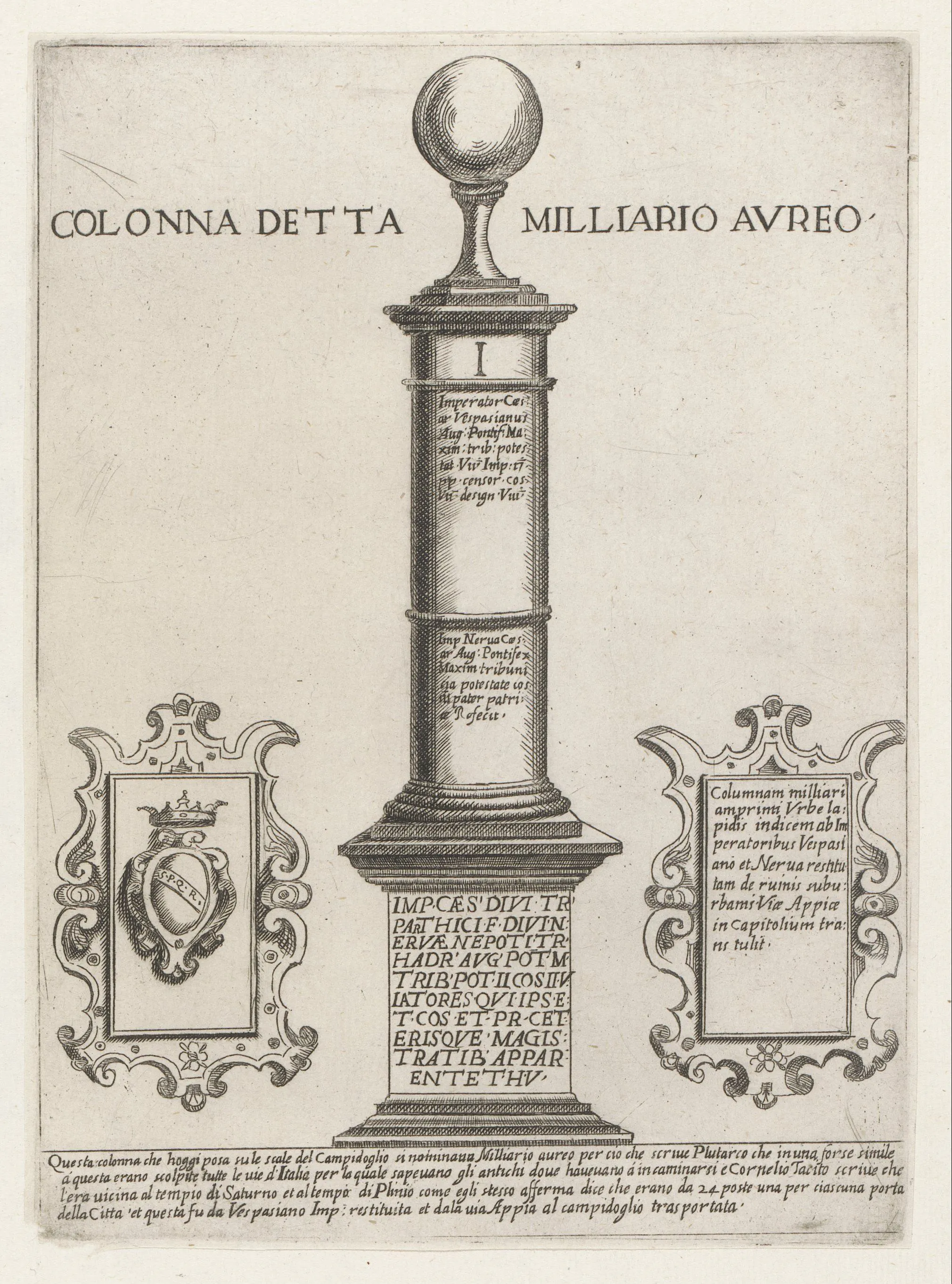
Giovanni Maggi's etching of 1651 presents the Milliarium Aureum as an inscribed column within an antiquarian frame, with printed Italian and Latin commentary set around the monument. As the reputed point in the Forum from which Roman itineraries were numbered, the Golden Milestone is precisely the kind of material origin Riccioli required for converting ancient road distances into measurable geography. Source ↗.
Book III: the Periegeticus and the warrant of the number
The final chapters of the third book, the Periegeticus, present the reforming programme in its most austere and least rhetorical form: the itinerary reduced to a chain of named stages and numbers, each chain carrying the name of the authority that vouches for it. The unit of composition is not the sentence but the stage, as in the coastal run from Cagliari along the African shore, where Riccioli sets down that from Cagliari to Carthage in Africa is 150 stades, thence to Hadrumetum 50, thence to Thapsus 100, thence to Cephalae 40, thence to Leptis Magna 100, thence to Alexandria 100, so Antoninus in the Maritime Itinerary, in which other African places too are mentioned, I. A Caralis in Africam Carthaginem Stadia 150. hinc Adumeton 50. hinc Thapsum 100. hinc Cephalœ 40. hinc Lepti magna 100. hinc Alexandrium 100. sic Antoninus in Itinerario Marituno, in quo alia quoque loca Africa mentio est.. Three features of the compilation are already visible here. The asyndetic hinc … hinc preserves the additive logic of the road or the coasting voyage, in which a distance is known only as the sum of its members and not as a measured interval between termini. The attribution is not decorative but functional: the number travels bound to the text that supplies it, exactly as, elsewhere in the work, a wind or a tide travels bound to the journal or the relation that reports it. And the closing clause, acknowledging that the source names further African places, concedes openly that what is printed is an excerpt: the compiler has selected, and says so, rather than presenting his list as exhaustive of the itinerary he has plundered.
The deeper difficulty of such compilation is that the sources do not speak in the same measure. Ptolemy's long maritime interval is given in stades, since from Marseille to Alexandria Ptolemy in the first book of the Geography, chapter fifteen, reckons 20,800 stades, II. A Masilia autem ad Alexandrium Ptolemæus lib. 1. Geograph. c. 15. computat stadia 20800.; within a few lines the same page-space is shared by Pliny's figures in Roman miles, and Riccioli converts silently in some places and not in others. That the numbers are reported rather than asserted is marked grammatically. Of the two great Tyrrhenian islands he writes that Corsica and Sardinia, if you may believe Pliny in the third book, chapter seven, are distant from one another by less than nine miles, Corsica autem, & Sardinia, si credas Plinio lib.3. cap.7. inuicem distant minus 9. mill.. The conditional si credas is doing precise work: it neither suppresses an implausible figure nor endorses it, but transfers the burden of credence to the named authority, leaving the reader in possession of both the number and its warrant. The same grading governs the juxtaposition of ancient with modern measurement, where, as he notes with a reference back to his own earlier discussion, Cluverius says that Corsica is 280 miles in circuit, while Isidore and Pliny in the third book, chapter seven, give Sardinia as 560, Cæterum vt suprà indicaui, Coriicam Cluerius circuire ait Milliaria 280. Sardinia Iidorus, & Plinius lib.3. c.7. 560.. A seventeenth-century geographer's perimeter and a patristic-encyclopedic figure stand in the same series, distinguished only by the names attached; the reader is equipped to weigh them, not relieved of the task.
The decisive pivot of the chapter is the turn from the ancient itineraries to the recent ones, and it is announced as a change of evidentiary regime: now, however, if we consult the itineraries of the more recent writers, from González de Mendoza and others we have that from Rome to Jerusalem is 800 Spanish leagues, which by what was said in the preceding book, chapter eight, number seven, make 2,400 Italian miles, but Duarte Barbosa affirms that they are 1,000 miles, as though indeed larger ones, V. Nunc verò recentiorum Itineraria si consulamus, ex Gonzalez Mendoza, & alijs habemus Roma ad Hierosolymas esse Leucas Hispanicas 800. quæ ex dictis libro antecedenti cap.8. num.7. faciunt milliaria Italica 2400. sed Odoardus Barbosa affirmat esse Milliaria 1000. quasi verò maiora;. Three operations are compressed into this single sentence. First, the missionary and mercantile literature of the sixteenth century — the Augustinian historian of China and the Portuguese factor of the Indian Ocean — is admitted as Itineraria on the same footing as Antoninus, Ptolemy, Strabo, and Pliny, so that the class of itinerary is enlarged to include the modern relation of travel. Second, the Spanish league is reduced to the Italian mile by an explicit internal cross-reference to the chapter of the second book that established the ratio; the folio is here operating as a system rather than a sequence, the earlier metrological book supplying the conversion factor that makes the later descriptive book commensurable with itself. Third, the reduction promptly fails: Barbosa's figure of a thousand miles cannot be reconciled with two thousand four hundred unless his miles are of another size, and Riccioli says exactly that, with the dubitative quasi verò maiora left standing as an unresolved remainder. The lesson is not that one author errs but that the names of measures are unstable across nations — the same difficulty that governs his treatment of place-names, transposed from toponymy to metrology. Nothing is smoothed away: the continuation of the same paragraph keeps reporting Iberian leucæ for the African and Levantine stages, and even reverts to the wholly anthropometric dietæ, days' journeys, between Damascus and Aleppo, a unit that cannot be reduced to a length at all without assumptions about the pace of travellers that the third book's second chapter had treated separately.
The following chapter, on the intervals of Hungary, Poland, Muscovy, Greece, and Turkey, returns almost wholly to the Antonine road-books, and its typographic habit is worth noting: the total of each route is set in Roman numerals as so many millia passuum, while the individual stages are set in arabic figures, so that the eye distinguishes the summed whole from its members at a glance, and printed marginal rubrics pairing origin with destination — Carinthia to Thessalonica, Byzantium to Ancyra, Byzantium to Ravenna — convert the columns into a consultable finding-list rather than a continuous discourse. Within these road-lists the same station recurs under divergent spellings, Gallicanum beside Gallium, Cenon beside Ceratae, Burdista beside Burdipta, the variants preserved rather than silently harmonized. And the chapter's last clause states the principle on which such divergence is allowed to stand: but since these itineraries vary in places, I do not insist, sed cum alicubi variet hæc itinerar. non insisto.. The formula is brief to the point of curtness, yet it performs the same office as the more elaborate confessions of uncertainty elsewhere in the work: where the collated testimony does not converge, the compiler declines to force a reading, and the reader is told that he declines.
The tome closes by declaring its own incompleteness as a plan rather than a defect. The remaining geographical matter is deferred: let the reader expect the other things that pertain to geography in the second tome, that is, in books V, VI, VII, VIII, X, and meanwhile let him not decline to proceed to the principal treatment of the first and fourth books, which are on chronology and hydrography, Cætera, quæ ad Geographiam attinet Lector expectet in Tomo secundo, hoc est in libris V. VI. VII. VIII. X. Interea qui pergendi ad tractationem præcipuam libri primi, & quarti, qui sunt de Chronologia, & Hydrographia, nolier. [reading uncertain], followed by the printed terminus, the end of the first tome, FINIS TOMI PRIMI.. This note is the most consequential structural evidence in the present stretch. It attests a two-tome economy for the twelve books; it enumerates the deferred books as the fifth through eighth and the tenth, passing over the ninth without comment; and it identifies the first and the fourth as the chronological and hydrographic treatments respectively — a numeration that does not agree with the scheme in which hydrography occupies the tenth book. The text before us therefore witnesses a state of the work in which the ordering of the books, and not merely their contents, was still in motion; the discrepancy should be registered as evidence of planning and issue variation rather than resolved by emendation.
The chapter-index printed for this tome confirms that reading and supplies the ladder by which the whole ascends. It designates the first book Chronologicus, on the measures of time, the second Stadiasmicus, on the measures of intervals, and the third Periegeticus, on the measuring of journeys; and its chapter titles show the deliberate progression from the smallest measures and the means of communicating them to foreigners and to posterity by the symmetry of the human body, through the ancient Roman, Greek, Egyptian, Hebrew, and Arabic units, to the palms, feet, cubits, paces, miles, and leagues of more recent nations, and thence to the mechanical modes of measuring distances, the hourly or daily velocity of walkers, couriers, and ships at sea or on rivers, and — decisively for the chapters just examined — to itineraries ancient and recent together with the fallacies to be avoided in using them, and to the reduction of an oblique route to a straight one through the same vertical circle. The itinerary lists are thus not raw accumulation but the application of a method announced in advance, one that presumes its own sources to be deceptive and prescribes both a geometrical correction and a metrological conversion before their numbers may be used. The index's page references, which run Book I to page 63 while Book II opens at page 31 and Book III closes at page 69, indicate more than one numbering sequence within the tome and caution against treating the printed foliation as a single continuous series.
Elsewhere in the same book the compilatory procedure is put under a strain that Riccioli does not conceal. Having assembled road- and sea-distances across Germany, Poland and Lithuania, then across the Mediterranean, Asia, Africa, the East Indies and the Americas, he pauses at the threshold of the most refractory of these bodies of material to explain why he will not do what a compiler is normally expected to do. He had resolved, he writes, to describe these intervals in order, collating at once the opinions of authors or writers and selecting from them those that seemed to him truer, but on account of the remarkable discrepancy that sometimes arises, I. Decreueram quidem ordinatim hæc interualla describere, conflando simul opiniones Authorum, seu scriptorum, & ex illis seligendo, quæ mihi veriores viderentur, sed propter insignem aliquando discrepantiam ortam, — and the sentence continues by locating that discrepancy in the differing use of leagues or miles and in the differing computation and skill of the pilots, concluding that it is more prudent to set out each authority's report separately and let the reader choose his source. The renunciation is methodologically loaded. It refuses the harmonizing impulse of the older cosmographies, and it treats numerical divergence as itself a datum about the state of the discipline rather than an embarrassment to be smoothed away. It also exposes a tension internal to the work's evidentiary hierarchy: the naucleri whose records elsewhere carry more usable knowledge than the speculations of the natural philosophers are here named as one principal source of variance, since their peritia is unstandardized and their leagues are not one another's. Practitioner testimony, admitted as a genre, brings its own irreducible scatter, and the reader is handed the adjudication precisely because no rule yet exists that could perform it.
What cannot be harmonized can nonetheless be reduced to a common measure, and the chapters work steadily at that reduction. The stadium of the Greeks, the leuca of the Atlantic navigators, and the units of the Chinese atlas are all brought back to the Italian mile as the work's standard currency of distance; the table drawn from Martino Martini's Atlas Sinicus states its rate of exchange openly, the measures being Chinese, of which twenty-five make six Italian miles, Sinensibus, quorum 25. faciunt 6. Milliaria Italica. Conversion is the minimal form of the reformatio announced in the title: it does not resolve which authority is right, but it makes their claims commensurable and therefore comparable. The same instinct governs the shift of literary form that interrupts the itineraries when the Mediterranean islands come up for treatment. Although not a few things about these islands may be found inserted in the preceding chapters, Riccioli notes, it has nonetheless seemed good to gather those and the rest into the following alphabetical catalogue, I. Vamuis hactenus non pauca de his Insulis inferta precedentibus capitibus reperire liceat, placuit tamen colligere illa, & reliqua in sequentem Catalogum Alphabeticum, sine. Discursive periegesis yields to a ruled table with columns keyed to a printed apparatus of sigla for Strabo, Pliny, Botero, Magini, Morisot and Crescenzi, so that the competing circumferences of Crete or Euboea stand side by side under the double nomenclature of Latin and vernacular. Scattered report is thus not adjudicated but arrayed, and the array is itself the instrument: a reader confronting Creta and Candia in one line, with three figures beside them, is being taught to hold discrepancy in view rather than to forget it.
Where arithmetic does permit decision, Riccioli decides, and here the geographer turns textual critic. Against a predecessor who had taken the received figure at face value he objects that the man was certainly deceived, and did not see that in Pliny the note L is erroneously superfluous, which being struck out there remain 3414 miles, sed profectò deceptus est, nec vidit in Plinio mendosè abundare notam L. qua expuncta remanent milliaria 3414. The emendation is ope ingenii in the strict sense, made without recourse to a variant witness and justified by the internal consistency of the number with the figures of Strabo and Polybius; it applies to a Roman numeral the same conjectural discipline that contemporary philology applied to corrupt words, and it implies that the numerals of the ancient geographers constitute a textual tradition with its own characteristic corruptions. The criticism then escalates from the transmission to the reasoning. Most ineptly, and without geometrical reasoning, Riccioli objects, did Pliny represent the magnitude of Europe by the addition of length and breadth, and he does the same there concerning Asia and Africa, Inceptissime tamen Plinius, & absque Geometrica ratione magnitudinem Europa repræsentauit per additionem longitudinis, & latitudinis. Quod etiam facit ibidem de Asia, & de Africa. The charge is not that Pliny's figures are wrong but that the operation performed on them is not an operation upon area at all; the remedy, reduction to square miles before comparison, asserts that magnitude is a properly geometrical quantity and that no accumulation of authority can substitute for the right kind of measure. Antiquity is here neither dismissed nor preserved intact: it is sorted, one clause at a time, into what survives the arithmetic and what does not.
The chapter on ancient navigation converts this sorting into narrative history, and its governing causal principle is commercial. Retailing Diodorus on the Iberian silver, Riccioli records that this being unknown to the inhabitants, Phoenician merchants acquired great wealth by that trade, and the gain so roused these merchants that, when silver overloaded their ships, they stripped the lead from their mooring-weights and put silver in its place, Quod incolis ignorum, ait Diodorus, Phœnices mercatores eo commercio opus contraxerunt; adeò autem mercatores hos quæstus auditas excitauit, vt cum omnibus nauius superaret argentum, amoro ab anchoris plumbo, argentum eius loco subduxerunt. The image of silver substituted for lead at the ships' moorings is made to bear an argument: Phoenician settlement in Sicily, Sardinia, Libya and Spain follows from the trade, so that colonization is the sediment of commerce rather than its cause. The same explanatory frame is then quantified when the Roman traffic with India comes up. Riccioli transcribes Pliny's complaint that it is a thing worth knowing that in no year does India drain less than fifty million sesterces from our empire, sending back wares that sell among us at a hundredfold, Dignares, id est scitu, nullo anno imperij nostro minus HS quingenties exhaustente India, & merces remittente, quæ apud nos centuplicaro veneant, and reduces the sum to Roman scudi in order to set the Roman outlay beside the yield of Solomon's fleet and the revenues of the Catholic King. The gesture is of a piece with the metrological work of the earlier chapters — ancient money, like ancient distance, is made commensurable with a modern standard — and it yields something close to a comparative economic history of long-distance seafaring, in which scripture, Pliny and the Iberian treasure fleets are entered in a single ledger of magnitudes.
The disputed questions of the following chapter show the same technique applied to authority of the highest order. Riccioli quotes Augustine's dismissal at length: that what they fable about the Antipodes, namely that on the opposite side of the earth, where the sun rises when it sets for us, men tread with their feet opposed to ours, is by no means to be believed, nor do they affirm that they learned this by any historical knowledge, but conjecture it as though by reasoning, Quod verò & Antipodis esse fabulantur, id est a contraria parte terra, vbi Sol eritur, quando occidit nobis, adversa pedis nostris calcare vestigia, nullaratione credendum est, neque hoc vlla historia cognitione didicisse se affirmans; sed quasi ratiocinando conieliant. The Father is not contradicted; he is historicized. His stated ground of refusal is the absence of historia cognitio, and Riccioli's observation that the testimony now available would have altered the answer turns Augustine's own epistemic criterion into the warrant for overturning his conclusion. The manoeuvre preserves patristic authority in the very act of setting its verdict aside, and it depends upon exactly the distinction between demonstrated, reported and conjectured knowledge that organizes the work elsewhere.
That distinction also underwrites the treatment of navigation before the magnet. Adducing Arrian, Riccioli notes that Hippalus was the first pilot who, having observed the situation of the emporia and the shape of the sea, discovered the navigation across the open sea, Primus, inquit, Hippalus gubernator, animaduerso empororum situ, ac marisfigura inuenit nauigationem per altum mare. The point is directed against those who make the pyxis magnetica the condition of blue-water sailing: seasonal wind-knowledge, acquired and retained by pilots, sufficed to take ships off the coast, and the discovery is credited to a gubernator rather than to a philosopher. The peopling of America is resolved by the same preference for natural means. Setting aside the fabulous genealogies which the Indians boast concerning their own origin, Riccioli answers that men reached America and its islands, first, by a land route, Respondemus vero prætermissis fabulosis genealogiis, quas de origine suâ lætant Iudi, peruenisse in American, atque eius infulas homines. Primo, itinere terrestris, before adding passage over straits, coastal and open-sea sailing, and involuntary storm-drift — a fourfold scheme that names miraculous or demonic transport only to exclude it. Its theological frame is the Pauline text that he cites according to that saying of Acts 17, that he has made of one all mankind to dwell upon the whole face of the earth, determining appointed times and the limits of their habitation, iuxta illud Aetorum 17. Festisque ex vno omne genus hominum inhabitare super venerjam saciem terra, defimendi statuta tempora. O terminos habuuntis eorum [reading uncertain]. Monogenism guarantees the humanity of the American peoples and simultaneously supplies a providential grammar of dispersal within which the leading out of colonies to uninhabited islands appears as the continuation of a divinely ordered distribution of habitations.
The annals of ocean voyaging
The annalistic chronicle that follows returns the reader from question to observation, and its most arresting entries are those in which measurement and natural history coincide. Of the Dutch wintering in the high north the text records that on 2 November the sun skirted the horizon under the seventy-sixth degree of latitude, that on the fourth it did not appear although the sky was clear, that with the sun the bears also departed and were not seen until its return, while the foxes came out as the sun departed and vanished as it returned, 2. Nouembris Sol Horizontem ambibat sub gradu 76. Poli, die 4. Sol non apparuit licet sereno oceo, cum Sole abierunt & Vrsl, nec nisi eo reduce visti; at Vulpes Sole abcunte prodiere, redeunne disparuere. Latitude, calendar date, celestial appearance and animal behaviour are entered in one continuous notation of the kind the work elsewhere defines as a diarium, and the entry acquires its analytical force a few lines later, where the premature reappearance of the sun in late January — an observation the voyagers themselves found astronomically impossible — is referred to refraction in the polar atmosphere. The chronicle thereby performs in miniature what the whole book has been doing: it takes the raw notation of navigators, submits it to a mathematical account that the navigators could not supply, and leaves both the report and its correction standing in the same column.
The register of ocean voyages that follows is ordered year by year, and the first judgement it passes sets the tone for everything after. Of the Portuguese India ship lost on the shoals off Mozambique, the text concludes that from this it is gathered that the shipwreck could have been avoided had they sailed that stretch not by night but by day, ex quo colligitur / potuisse vitari naufragium si non de nocte, sed in / terdiu tractum illum nauigassent. The inference is small but methodologically consequential: disaster at sea is entered in the annals as a fault in navigational judgement, susceptible to rule, rather than as an inscrutable visitation. The annalistic form — marginal year-headings, departure port, dates, latitudes, landfalls, outcome — is thereby made to serve a prescriptive end, since a catalogue of errors is also a catalogue of precepts in negative form. This is the same evidentiary reflex that governs the later hydrographic material: the records of those who sail are admitted as knowledge precisely because they can be compared, weighed, and turned into instruction.
The register's density increases around the Le Maire–Schouten passage of 1615–17, and with it the text's attention to the act of naming. The land that appeared on the western side of the strait was called Maurice of Nassau, that on the eastern the Land of the States, or Staten Land, Terra, quæ ab occidentali parte freti videbatur, / dicta est Mauriti de Nassau, quæ ab orientali Terra Ordinum, / seu Seaten Landi. Riccioli records both the Latin form and the Dutch, exactly as his onomastic principles require, and in doing so preserves the moment at which the constitutional vocabulary of the Republic — a stadholder and the States General — was fixed upon the southernmost coasts of the globe. Toponymy here is not a lexical curiosity but the trace of a political act, and the register keeps the vernacular form beside the Latinism because the two are evidence of different things: what the discoverers said, and what the learned may write.
The chronicle then registers, without editorializing, two collisions that discovery immediately provokes. The first is juridical and internal to the Dutch: at Jacatra the governor of that place, by mandate of the Indian Company, announced that Jacob Le Maire's ship and all his goods were to be burdened with arrest and detained, vbi loci illius præfectus, ex mandato / Indicæ Societatis, nauem Iacobi Maire bonaque omnia / ipsius arresto grauari, ac detineri denunciavit. A new route found in evasion of a chartered monopoly is confiscated by that monopoly's own officer; the text reports the legal formula (arresto grauari) with the same neutrality it gives to a latitude. The second collision is imperial: the Catholic King's captain set out from Lisbon in October with orders to build fortifications on each shore and to shut off the passage to others, Soluit ille Vllysipone Octobri cum mandatis construendi / in vtroq[ue] littore fretj munimentis ad alijs intercludendi / transitum. Geographical knowledge and strategic exclusion are shown as a single motion, and the observation reported from the same reconnaissance — that the strait proved minus latum quam tabulæ Hollandicæ repre, less wide than the Dutch charts represent — quietly implicates the charts themselves in the contest.
The chapter that follows converts the chronicle's implicit method into an explicit one. Since in the preceding chapter we indicated only selected matters, by way of compendium and as if by a certain leap, if anyone should wish to know more of what is noted in the aforesaid navigations, it seemed good to review for the reader the chief writers or collectors of these navigations in the following little index, Q Voniam præcedenti capite selecta tantummodo per compendium, & quasi saltu quodam indicauimus, si quis plura scire cupiat / notata in prædictis nauigationibus; placuit / Lectori recensere præcipuos harum Nauigationum Scripsores, aut Collectores, sequenti indiculo. The admission of selectivity (selecta tantummodo, quasi saltu quodam) is paired with a remedy: the compiler acknowledges that his abridgement is an abridgement and hands the reader the means of going behind it, from Arrian and Hanno to Ramusio, Herrera, the De Brys and Purchas. Compilation is here disciplined by citation, and the indiculus functions as the warrant of a summary that does not pretend to be a source.
From chronicle the book turns to sailing directions, and with the turn comes the sharpest statement in this portion of the work of what a rule can and cannot do. Distinguishing the voyage made with fair winds from the voyage harassed by calms, storms and contrary currents, Riccioli states that the former admits fixed rules, the latter can scarcely be comprehended by any precepts, prior eum Regulas certas admittit posterior vix vllis / præceptis comprehendi potest. This is the timing chapters' equivalent of the distinction between geometrical rigour and physical sufficiency: the tabulated durations of the Lisbon–Goa or Manila–Acapulco runs describe an idealized passage, and their author says so before the reader can discover it. That the prescriptive apparatus is nonetheless enforceable by more than prudence appears in the treatment of the Brazilian coast, where the Portuguese must also be particularly careful not to approach Cape São Agostinho so closely as to see it, otherwise they are bound under pain of death to return to Portugal, Cauendum / etiam periculariter Lusitanis, ne ita ad Caput S. Augustini accedat, vt illud videant, alioquin sub poena capitis / tententur redire in Lulitaniam. A monsoon calendar has been codified as capital law, and the geographer registers the fact as one more datum of the route.
The northern chapter yields the most philosophically interesting outcome of the voyage books, because its result is a negative one held to be useful. Of the Arctic attempts Riccioli writes that with regard to their primary end, which was a route through the Tartar Ocean to Cathay, China and the Moluccas, no other advantage resulted from it than that mortals should recognize that the way through the Northern Ocean to China and the Moluccas is either impossible or denied to these ages, spectato tamen primario sine ipsius, qui erat / iter per Oceanum Tartaricum, ad Catham, Chinam, / Moluccas, struita huc, nec alia inde vtilitas extitit, quam / vt agnoscerent mortales, aut impossibilem esse, aut laculis hisce denegatam viam per Oceanum Septentrionalem ad Chinam, Moluccas, &c. The disjunction is carefully left open — impossible simpliciter, or merely denied to this age — so that failure is recorded without being converted into a metaphysical claim about the globe; and the failed enterprise is credited with an vtilitas of its own, the elimination of a hypothesis.
The demarcation chapter applies the same instinct to a juridical question. Alexander VI, Supreme Pontiff, having therefore been chosen arbiter by consent of the parties, lest the suit should at some time break out into war, having consulted geographers and taken cognizance of the case, ordered two meridian lines to be drawn from Pole to Pole, Electus igitur de consensu partium arbiter Alexander VI. Sum. Pontif. ne, / quando lis in bellum crumperat, consultis Geographis, / & cognita causa; iussit duci duas lineas Meridianas à / Polo ad Polum. Every clause does work: the papal role is arbitral and consensual rather than dominative, the motive is the prevention of war, and the decision rests on geographical consultation — that is, on the very expertise the present volume professes. Riccioli then withdraws from the legal question itself with the disclaimer, whether however the civil right be preserved, which is nothing to us, An autem saluo iure ciuli, de quo nihil ad nos,, leaving civil right to the jurists while reserving the computation of the meridians to himself. The later phase of the quarrel receives an epigram: concerning the third suit, stirred up in 1527 between the Portuguese and the Castilians over the right to the Moluccas, it was settled not by iron but by gold, De lite porrò tertia quæ Anno 1527. excitata / est inter Lusitanos, & Castellanos super iure Moluccarum, / vide quæ cap. 22. diximus ad hunc annum; fuit / enim dirempta non terro, sed auro — the antithesis non ferro, sed auro compressing the Treaty of Zaragoza into a transaction.
The Bolognese survey and the magnitude of the globe
With the geodetic book the discipline changes and the reforming programme becomes explicit and local. The Bolognese survey is undertaken, in the author's own words, that we might resolve the ancient and ever-new question concerning the magnitude of the whole terraqueous globe, and at the same time offer a specimen of geography to be reformed by more accurate chorographic descriptions, Vt antiquam, semperque novam questionem / de Magnitudine insta Orbis Terraquei / solucremus, & simul Geographiæ per accuratiores / Chorographicas descriptiones / reformandæ speciem præberemus. The word reformandæ appears here in its working sense: a base line measured from the Porta S. Felice and a chain of triangles over Monte Paterno are offered as the pattern by which the discipline at large is to be emended. Collaboration is named rather than absorbed: let it now be granted me to name the aforesaid compass the Grimaldic Compass, because Father Francesco Maria Grimaldi used one of this form very often for our sake, and most accurately, over many years, with me for the most part present and assisting, Detur iam mihi Compassum prædictum nominare Compassum Grimaldicum, quia tali forma sæpissimè / in noltri gratiam, & accuratissimè per plures annos vius / est P. Franciscus Maria Grimaldus, me plerumq[ue] præsente, & adiutore. Eponymy is here an act of credit within a religious house's research practice, the instrument carrying the name of the man who worked it rather than of the author who publishes it.

Joan Blaeu's engraved plan of Bologna sets Riccioli's geodetic reform in the walled city whose streets, gates, and approaches formed the practical setting for Jesuit measurement. Against this urban ground the base line from the Porta S. Felice and the labour credited to Grimaldi appear not as abstract claims but as local acts of observation, instrument use, and publication. Source ↗.
The same ethic governs the critique of others, which is licensed by a prior self-correction. Nor ought it seem hard to anyone if we, who in our earlier geodetic exercises candidly confess and publish our own errors, should note similar errors of others, arisen from similar causes, so that they may be avoided by others, Nec / vlli graue videri debebit, si Nos, qui in prioribus nostris / Geodæticis exercitationibus errores nostros candidè fatemur, & vulgarmus; / aliorum similes errores, & a similibus causis ortos notemus, vt ab alijs / deusentur. The right to examine Snell's chain of triangles is earned by having published one's own discrepancy, and the purpose is prospective — vt ab alijs deuitentur. Metrology receives a parallel criticism directed at the printed atlas: against a single scale bar Riccioli objects that its author wished to use one species or quantity of feigned miles, which in fact does not exist, for Italian miles are not everywhere in Italy of the same measure, but very different even in neighbouring places, At iple voluit vti vna specie, aut / quantitate Milliarium ficta, quæ reipsa non datur. Neq[ue] enim Millaria / Italica sunt vbiq[ue] in Italia eiusdem mensura, sed in vicinis quoq[ue] locis / valdè diuersæ. The remedy proposed — several distinct scales on each regional sheet — accepts metrological pluralism as a fact of the territory rather than legislating it away, and the chapter's conclusion ranks the evidence accordingly, holding it clear that for reforming geography through chorographies of particular places, intervals apprehended by geodetic measurement by geometers — but not vulgar ones, nor from hearsay — are to be preferred, Ex hactenus dictis parere tam arbitror ad reformandam Geographiam, per / Chorographias particularium locorum, preferenda esse interulla Geodaticis / dimensionibus à Geometris, sed non vulgaribus, nec de trauio deprehensa.
The geometrical book frames that exactitude within an acknowledged ceiling. To attain the most exact measure of the terraqueous globe, so that you do not err by some hundreds of paces, is not within human industry; but God has granted that we may nevertheless come very near to it, Reuera enim exquisitissimam mensuram. / Terraquei globi assequi, itant aliquot centuris / pallium non aberres, non est humanæ industria; sed ad / eam tamen proxime accedere concessit Deus. Approximation is thus theologically licensed rather than merely tolerated, which is what permits the ensuing dismantling of the ancient measurements to proceed without impiety toward the authorities dismantled: of Eratosthenes' celebrated procedure it is granted only that a paralogism lurks in it, and certain other things obstructing an accurate demonstration, have already been shown, Nihilominus paralogismum in ea latere, & alia quædam accuratæ apodixi officientia, oftenderunt. The fault is logical, not moral, and it is corrected by the philological lever the same book supplies, the argument that the Egyptian measurers used the Alexandrian stade, Mihi enim / certum moralitet videtur Erathonem, & Regios Ægypti / metatores vsos fuisse stadio Alexandrino — a conclusion offered, characteristically, as morally certain rather than demonstrated, so that an ancient figure may be reconciled with a modern one without either being falsified outright.
Book VI: the Altimetricus — mountains, clouds, and the refractive air
Book VI, the Altimetricus, closes with three chapters that test the reach of trigonometrical measurement against progressively less tractable objects: a mountain known chiefly from ancient testimony, a cloud, and the atmosphere itself. The first of these, on the height of Mount Athos, begins not from an observation but from a dossier. Isidore of Charax, Solinus, Vitruvius and Pliny are laid side by side on a single reported fact — that at the summer solstice the shadow of Athos reaches across the Aegean to the market-place of Myrina on Lemnos — and the ancient literature of wonders is allowed to speak at length, including the claim that Athos rises above the clouds, reported by Solinus in terms that Riccioli transcribes as testimony rather than as fact, that Mount Athos in Macedonia is so lofty that it is believed to be higher than the clouds, At Solinus cap.16. Athos mons Macedoniæ vsque adeo altus est, vt credatur altior esse nubibus.. The surrounding matter — ash heaped on the altars because no rain washes it away, the long-lived Macrobii of the town of Acte, Xerxes cutting the isthmus and passing his fleet — is precisely the repertory of wonders that a reforming geography must decide how to handle. Riccioli's decision is to strip the report to the one quantity it can be made to yield: the length of the solstitial shadow, which is to say the distance from the peak to the western part of Lemnos. Everything else in the ancient notice is retained as erudition and excluded from the computation.
That single quantity, however, is not available in any settled form, and the chapter's second movement is a candid display of the disagreement among the sources of distance themselves. Ptolemy's tables place the eastern apex of Athos and the island some four degrees and twenty-six minutes apart in longitude; the moderns give Athos a longitude of forty-three degrees rather than fifty-one; and the great commercial atlases dissent from Ptolemy by a wide margin, a divergence Riccioli states and immediately converts into a methodological ruling, namely that the tables of Mercator, Jansson, Blaeu and Sanson depart greatly from these, since they scarcely allow two degrees, so that from Pliny, Solinus and the moderns' manner of measuring, the distance is to be defined by eighty-seven miles rather than by a distance in degrees, quibus multum recedunt Tabulæ Mercatoris, & Iansonij, Blaeu, & Sansonij, quæ vix ponunt Gr. 2. quare ex Plinio, & Solinio, & recentiorum modo mensurandi distantiam per milliaria 87. potius quàm à distantia in gradibus definienda est.. The preference is worth dwelling on, because it inverts the hierarchy one might expect from a mathematical geographer: the graduated coordinate grid, the discipline's most refined apparatus, is here judged the weaker datum, and the linear mileage drawn from itinerary tradition and chart practice is preferred. The ground of the preference is not that miles are more exact in principle but that on this particular interval the degree-values of the received tables cannot be reconciled, whereas the mileages, though also disputed — Ferrari and the more careful charts of the Archipelago give at least a hundred, while Sanuto's forty-six is dismissed as scarcely tolerable — cluster within a range that the computation can absorb as a stated pair of alternatives.
The third difficulty is onomastic, and Riccioli's handling of it shows how the work quarantines an unresolved question so that a measurement may proceed. Baudrand contends that the true Lemnos or Stalimene now so called lies on the western shore of the island near the gulf of Talamiti, and that the town commonly given that name is in fact Hephaestia; the recent charts mark the eastern city, popularly Palio Castro. Riccioli refuses to adjudicate, omitting here whatever is true or false concerning these names and considering only this, that the shadow of the peak of Athos reached the western part of the island of Lemnos or Stalimene, Nos hic quidquid est veri, aut falsi de his nominibus omittentes, solummodo hoc consideramus, vmbram Athonis apicis peruenisse ad occidentalem partem Lemni, seu Stalimenis Insulæ.. The geometry requires a place, not a name; the nomenclatural dispute is therefore suspended rather than settled, and the minimum on which the two contending authorities agree — a location on the western side — is extracted as the operative premise. This is the same instinct that governs the work's repertory of names, applied here in miniature and under geometrical discipline.
The computations that follow are then run twice, and the doubling is the point. Taking Pliny's eighty-seven Roman miles, which answer to about sixty-nine and a half Bolognese, the arc subtended at the Earth's centre is one degree five minutes, and the secant applied to the Bolognese semidiameter leaves the height of Athos at six hundred and twenty-seven Bolognese paces; taking instead a hundred Bolognese miles, the arc becomes one degree thirty-four minutes and the height rises to one thousand two hundred and ninety-one. A result that more than doubles on the substitution of one contested premise is not concealed, and the supposition underlying both is stated explicitly, together with the consequence that on this reckoning the mountain must be much smaller than the ancients allege, In hac supputatione supponimus umbram Athonis in ipsa dici Solistialis Vespera tanto Solis à Meridiano occidentali receslu, obtinuisse extremum suum terminum in occidentali parte insulæ Lemni; quo caiu sanè, & mons Athos maximus quidem, sed multo minor prædictis fuisse videatur [reading uncertain]. Against the seventy-six thousand paces implied at the chapter's opening, figures in the hundreds are a drastic deflation, and it is achieved not by denying the ancient report but by taking it seriously enough to compute with it. The chapter then adds, for the case in which Athos is conspicuous in its whole height to those sailing, two trigonometrical routes using the observed distance of the Sun from the summit or its apparent altitude above the physical horizon — a reminder that even in the altimetric book the standing observer is often imagined on the water.
Chapter XVI carries the same instruments to clouds and announces at once why they will not serve so well: clouds possess neither the determinate figure nor the fixed position of mountains, so that their altimetry may be disturbed within a small moment of time, and the vapours beneath them, thick for several miles, refract the visual ray and raise the cloud apparently higher than it is. Three procedures are nonetheless given — two stations with simultaneous observation coordinated by a clock, one station with two distinguishable parts of the same cloud, and, most economically, no angular observation at all where the same cloud stands at the zenith of one place and on the physical horizon of another, the terrestrial arc alone supplying the angle. The verdict on all three is stated as a grade of certainty rather than a result, that from these the heights of clouds can easily be determined in like cases, yet not exactly, for the reasons touched at the beginning of this chapter, Ex his facilè poterunt determinari altitudines nubium in casibus similibus, non tamen exactè, ob rationes initio huius capitis attactas.. Only then does the doxography appear — Blancanus at two or three Italian miles, Cabeo at twelve — with the observation that such figures depend partly on the terrestrial magnitude and partly on the mountain heights their authors assume, and hence that the Peripatetic doctrine that clouds never rise above summits, with Olympus as its standing instance, rests on the same borrowed quantities. Riccioli answers this with autopsy: sometimes in the Rhaetian Alps and in the Serra Paterni he observed clouds so high that they surpassed the peaks, and more often, and in lower mountains too, he observed clouds between summit and base, creeping along their flanks, so that it frequently rains in the deep valleys while on certain summits the weather is clear, Ego quandoque in Alpibus Rhætijs, & in Serra Paterni observaui nubes ita altas, vt superarent Montium cacumina, & sæpius, atque etiam in inferioribus montibus, obseruaui nubes esse inter cacumen, & radices montis, immo & irrepere per illorum latera, ideoque sæpe pluere in imis vallibus, cum in verticibus quibusdam montium serenum sit tempus.. Repeated personal observation, graded by frequency — quandoque against sæpius — is here admitted as an evidentiary register in its own right, and it does not merely contradict the ancient topos but explains it: a clear summit above a raining valley is exactly what Solinus's rainless peak would look like to a reporter below.
The final chapter extends the enquiry to the refractive and the vaporous or crepuscular air, and its first labour is commensuration. Alhazen's fifty-two miles, reckoned six to a degree, are reduced to about five and a half Bolognese, that is five thousand five hundred paces; Kircher's three and a half Italian miles, Blancanus's two and a half, Snellius's two and a half falling to two, and Kepler's twelfth part of a German mile, itself a third of an Italian, are all restated in the same Bolognese paces. Reducing incompatible units to one standard is what makes the spread — from fifty-two miles to some three hundred paces — legible as disagreement rather than as mere variety of idiom. Cabeo's caution that the air over land and sea is never of one density, and that vaporous refraction is greater in the east than in the west, is accepted, and Riccioli adds his own doubt drawn from the notorious variability of horizontal refractions. The remedy is deferred and made conditional upon his astronomical work, for should his table of refractions be received, the one employed throughout the first volume of the Almagestum Novum and to be repeated below, he will then also deliver a method of determining the height of the refractive air, Quod si Nostra Refractionum Tabula recepta fuerit, quæ toto Almagesti Noui Tomo 1. usurpata est, & quam infra Repetemus, tunc etiam methodum tradenus determinandi Aeris refractiui altitudinem.. The promise is doubly hedged — on the reception of the table by others, and on its reprinting later in this volume — and it documents a specific, checkable dependence of the geography upon the astronomy rather than a general appeal to the author's prior authority. For the crepuscular air an interim construction is supplied in the meantime, the Sun eighteen degrees beneath the horizon at the beginning or end of twilight yielding, with the secant of seventy-two degrees, the roughly forty-two Italian miles of Pedro Nunes and Clavius against the fifty-two of Alhazen and Witelo. Book VI then ends by refusing to choose: the exact arc at which twilight begins and ends is not established, the crepuscular light reaches us by refraction as well as by reflection, and the density of the vaporous air is nowhere uniform, so that the subject is declared sufficiently touched upon and the book closes on a measured statement of what its own numbers cannot bear.
Those same chapters repay a closer pass, for the evidentiary work that precedes their geometry is as deliberate as the geometry itself, and the Athos dossier opens in the middle of an assembly of witnesses rather than a demonstration: before Riccioli can measure the mountain he must establish that there is anything to measure. Having collated Solinus, Pomponius Mela, Plutarch, the Suda and Belon on the shadow cast into the marketplace of Myrina, he refuses to dissolve the report into a figure of speech, declaring that it is therefore not a poetic exaggeration but historical truth, confirmed by constant report and indeed by evident observation, that Valerius Flaccus sang thus in the first book of the Argonautica, I. Non est igitur Poetica exaggeratio, sed veritas / historica, constanti fama, immo euidenti obseruatione / firmata, quod Valerius Flaccus lib. 1. Argonauticorum / ita cecuit. The category of veritas historica does the work that physicè does elsewhere in the volume: it names a grade of certainty below geometrical demonstration but above conjecture, and it is constructed out of an ascending triad — fama, then observatio, then the verdict veritas. Poetic testimony is admitted not as ornament but as the residue of observation, and the poets are thereby enrolled among witnesses whose statements can be reduced to quantity.
The reduction, however, must be done correctly, and the chapter's next movement is a piece of exact censure directed at the most conspicuous Jesuit authority in the field of light and shadow. Riccioli objects that in this figure a double pseudographia lies hidden, the first being that Kircher posits the ray terminating the shadow to be DAC, issuing from the sun's centre, since he uses the sun's altitude, which is commonly referred to its centre, I. Sed in hac figura duplex latet Pseudographia. / Prima est, quod ponit radium terminatium vmbra / esse DAC, profectum ex centro Solis; vtritur enim altitudine / Solis, quæ communiter refertur ad centrum eius. Pseudographia is imported from the vocabulary of Greek geometrical polemic, where it denotes a faulty diagram rather than a false opinion, and the term's precision is the point: Kircher's error is not arithmetical but a mismatch between the geometry drawn and the physical object referred to, since the shadow's edge is determined by the solar limb and not by the centre to which tabulated altitudes are reduced. The fifteen minutes of semidiameter thus omitted are compounded by the second fault, that a mountain's true and absolute height is the whole perpendicular dropped from the summit to the convexity of land and sea, so that the excess of the secant over the terrestrial semidiameter must be counted in. Correction here is not the replacement of one authority by another but the imposition of a consistent datum-surface upon a figure already drawn.
Geometry alone, though, cannot decide whether the shadow reaches Myrina, and the chapter accordingly turns to a living witness, a Jesuit born on Naxos who had obtained the Constantinople mission. Riccioli certifies him in the idiom of testimony rather than of natural philosophy, noting that he is moreover a man of most religious good faith and of sound judgement, Est autem vir religiosissimæ fidei, / & æris iudicij; fides and iudicium are the qualities a court requires of a deponent, and their invocation shows how a quantitative result could rest, at its base, on a moral appraisal of the informant. The deposition itself is rendered with the specificity that makes it computable: in the year 1658, on the second day of April, Father Angelo Loredano reached the north-western shore of Lemnos and stayed there three days, and on the last two, because he knew of the memorable report about the shadow of Mount Athos overshadowing Lemnos, he observed the sun half-hidden behind the summit of Mount Athos three quarters of an hour before sunset, IX. Anno 1658. d. P. Angelus Loredanus die 2. Aprilis / peruenit ad Lemni littus Boreoccidetale, ibique triduo mansit, duobus vltimis diebus, quia sciebat memotabilem esse famam de vmbra Montis Atho Lemnum inumbrante, obseruauit Solem semilatetem post cacumen / montis Atho, tribus quadrantibus ante occasum Solis;. Every element of the ancient topos has been converted into a parameter: date, shore, bearing, and above all the interval before sunset, which alone supplies the solar altitude and azimuth from which the height can be extracted. The witness is even said to have gone knowingly in search of the fama — an observation framed in advance by the textual tradition it will confirm.
The passage from deposition to calculation is marked by a hinge of two clauses, thus he; now from History to Mathematics, Hæc ille. Nunc ab / Historia ad Mathesin. The formula states the treatise's methodological signature with unusual economy: history and mathematics are not competing genres but successive operations upon the same material, the first securing the datum and the second grinding it. What emerges from the mill is a number and the record of the technique that produced it, for by accurate trigonometry the height MD of Mount Athos is drawn out as 12192 Roman paces, since the logarithmic operation stands thus, quibus per / accurratam Trigonometriam eruitur Montis Atho altitudo MD, Passuum Romanorum 12192. Nam ita se / habet Logarithmica operatio. The displayed logarithmic working is itself part of the argument, since it exposes the procedure to audit; and the designation of the result as MD rather than AB keeps visible the corrected definition of absolute height won from Kircher. A further problem, admitting parallax and a layered refracting atmosphere, then reduces the claim to a floor rather than a measurement — a minimum height, beneath which the observation cannot be satisfied — which is the same discipline of marked certainty that governs the work's nautical books.
Philology returns as a technical instrument in the following chapter, where the contested illumination of Caucasus at dawn and dusk had generated estimates ranging from fifteen to more than seventeen hundred miles. Riccioli locates the entire disorder in a construal of the Greek, supposing thirdly that it is by far the truest that Aristotle spoke of the third part of the mountain and not of the third part of the night, which the interpreters would surely have recognised had they weighed the genuine and almost obvious sense of his text from the Greek context, XI. Tertio suppono longè verissimum esse Aristotelem / locutum esse de tertia parte montis, non autem de / tertia parte noctis, quod sanè interpretes agnouissent, si / textus ipsius genuinum, & ferè obuium senum ex contextu / Græco expendissent. A physical magnitude of three orders of dispute is thus made to depend on the referent of a genitive, and the grammarian's competence becomes indispensable to the altimeter's. The reading is buttressed by a control internal to Aristotle: when the Meteorologica reaches the far north it adds that under the Bear itself, above furthest Scythia, are those called the Rhipaean mountains, about whose magnitude the reports that are bandied about are exceedingly fabulous, hæc subiungit: Sub ipsa autem Arcto supra vltimam Scythiam, / qua vocantur Riphæa, de quarum magnitudine sermones, / qui iactantur, valdè sunt fabulosi. Because Aristotle marks one report as fabulous and leaves the other unmarked, his silence is read as credence — an argument that turns the philosopher's own critical vocabulary into a gauge of his assent, and that mirrors Riccioli's habit of grading his own claims by explicit label.
The polemical chapter that answers objections to great mountain heights states the hierarchy of evidence outright, insisting that it is not the mark of a sound intellect to abandon a truth laid open by mathematical demonstrations because of the narrowness of certain opinions, proceeding either from the deceit of sense and imagination or from weak reasons and flimsy arguments, sed non est sani intellectus veritatem / demonstrationibus Mathematicis patefactam, / deferere, propter angustias opinionum quarundam, / profectas vel à fallacia sensus, & imaginationis, vel ab / infirmis rationibus, leuibusque argumentis. The angustiae opinionum are diagnosed as failures of imagination as much as of reasoning, and the remedy offered is institutional as well as intellectual: Father Francesco Maria Grimaldi, demonstrating publicly and in an assembly of most expert mathematicians, especially the most excellent professors of mathematics in the Bolognese archigymnasium, Giovanni Domenico Cassini and Pietro Mengoli, that the height of Athos is not less than twelve Roman miles, P. Francisco Maria Grimaldo / publicè, & in / concessu peritissimorum Mathematicorum, præsertim / Excellentissimorum Matheseos in archigymnasio Bononiensi / professorum Io. Dominici Cassini, & Petri / Mengoli, demonstranti Athi altitudinem non minorem / Milliaribus Romanis 12, was met, as the sentence goes on to report, by philologists who muttered in private while the professors attested that the demonstration was limpid. The notice is valuable as a record of the theatre in which a mathematical result was ratified in Bologna, and it inverts the earlier alliance with philology: grammar is decisive when it fixes the sense of a Greek text, and worthless when set against a demonstration it cannot follow.
Levelling, the Reno, and the turn to latitude
The same corrected datum-surface that governed the height of Athos becomes, in the levelling chapters, the foundation of an applied hydraulics. Its definition is stated as the equilibrium of the terrestrial orb, or of the earthly globe, being its spherical surface, Æquilibrium Orbis Terra, seu Globi Terranei, est superficies eius sphærica — the sphere of the sea at rest, continued in thought beneath mountains and masonry, against which every gradient and every plumb-line must be reckoned. From it follows the analysis of the great gnomon of San Petronio, where the angle formed with the pavement cannot be strictly right because the vertical converges on the earth's centre, and from it follows too the critique of instruments. Riccioli's procedure with the latter is to quote the ancient text entire and then improve upon it, reproducing Vitruvius to the effect that the leveller works with dioptrae, or water-levels, or the chorobates, but they achieve it more accurately with the chorobates, because the dioptra and the level deceive, the chorobates being a rule about twenty feet long, Librator autem / Dioptris, aut libris aquarijs, aut Chorobate: sed diligentius / efficiunt per Chorobatem, quod dioctra, libraq[ue] fallum. / Chorobates autem est regula longa circiter pedum XX. The Greek etymology, Barbaro's reconstruction of the figure, and then a hydrostatic level of the author's own design with crystal tubes follow in order: the ancient authority is edited, illustrated, and superseded in a single movement, which is precisely what reformata denotes.
All of this apparatus is finally spent on a dispute of the Legations. Whether the Reno, readmitted to the Po near Ostellata when both rivers run at their fullest, would overtop the embankments of the Ferrarese was a question of papal territorial administration, settled here by computation from documented inspections; and the verdict is issued with its conditions attached, for Riccioli thinks he can report with certainty that the Reno will never add more than one foot to the Po, indeed not even a foot unless the Reno at its fullest enters the Po at its fullest, Interim certo mihi renunciare posse videor nunquam / Rhenum additurum Pado plus vno pede, immò / nec pedem, nisi Rhenus plenissimus ingrediatur Pædum / plenissimum. The double superlative is the load-bearing qualification: the maximum is real only under a conjunction of two independent maxima, and the certainty claimed is expressly a certainty about an upper bound rather than about an event.
Book VII: the Geoplaticus and the altitude of the pole
The Geoplaticus then takes up the latitude of terrestrial places, and its early chapters proceed by accumulating methods for the meridian line — tree-rings, the equinoctial shadow, equal ante- and post-meridian shadows after Vitruvius, equal altitudes of a star, and Tycho's maximum digression of a circumpolar star — before turning to the magnet. There the aspiration is stated as a proposition: a magnetic versorium suspended in equilibrium is inclined below the horizon in different degrees according to the different altitude of the pole, Versarium Magneticum suspendum in equilibrio inclinatur infra Horizontem diuersimodis pro diuersa Poli Altrudine. With a comparative register of dips observed at London, Rouen, Tours, Rome and Metz assembled beneath it, the proposition holds out the prospect of reading latitude from the needle alone; the collation of discordant values from Gilbert, Cabeo, Grandami and Kircher is what the chapter offers in place of a rule, and the tabulation of the discrepancy is itself the reform.
Organized as it is around that single quantity, the altitudo poli, the book proceeds by testing in turn each technique by which it might be had. The assessment of magnetic dip is introduced not as doctrine but as a first-person navigational report from a voyage out of Lisbon, in which readings taken with a dip circle are checked against the tables of Gilbert and Briggs, found to fail near the equinoctial line, and found further to diverge by a systematic ten degrees according to whether the instrument faces east or west south of the line. The verdict drawn from this is stated as a law of restriction: from these things, Riccioli writes, we gather that the northern part of the needle is raised beyond the equator and the southern depressed below the horizon, but that in the quantity of the inclinations the same laws are not preserved as on this side of the equator, and that particular observations are needed, Ex quibus colligimus partem Borealem Versorij vltra Æquatorum eleuari, & Australem deprimi infra horizontem, sed in quantitate Inclinationum non seruari caldem leges, quæ citra Æquatorum & opus esse peculiaribus obseruationibus. The structure of the sentence is worth noting: the qualitative behaviour of the versorium is conceded to hold universally, while the quantitative rule — the part that would make dip a latitude technique — is confined to one hemisphere, and the deficit is converted immediately into a demand for further observation rather than into a speculative repair. The chapter's closing judgement generalizes this: from which it appears that the experiment is slippery, and does not lead us exactly to the true elevation of the pole, Ex quibus apparet lubricum esse experimentum, nec exactè nos manuducere ad veram Altitudinem Poli. Lubricum is the book's standing term for a procedure that presents an appearance of exactness while yielding discordant results among observers, and it belongs to the same graded vocabulary that elsewhere separates what holds in geometrical rigour from what suffices physically. Characteristically, the rejection does not suppress the apparatus: the propositions on the terrella, the trigonometric construction taken from Gilbert through Kircher, the description of an instrument built from two thin brass laminae in the shape of a small boat with its needle hung by a woman's hair, and Kircher's complete table of northern inclinations degree by degree are all printed regardless. Method is condemned and tabulation survives, because the table remains usable for other ends and because the reader is to be shown the grounds of the verdict.
The gnomonic chapters that follow supply the book's most consequential technical intervention. Having reviewed the obelisks of Egypt and the meridian instrument of the Campus Martius through Pliny, and having diagnosed Pliny's perplexity as ignorance of two causes, the shifting moment of the equinox and the settling of a trodden pavement, Riccioli turns on Ptolemy's own grounds for distrusting the shadow method and identifies a different and prior error: the ray BDI, which terminates the equinoctial shadow, is not propagated from the sun's centre but from its uppermost limb, Radius enim BDI, terminator vmbræ æquinoctialis, non propagatur à centro Solis, sed à supremo eius limbo. The point is optical and almost trivially simple, and precisely for that reason it is devastating in application: the ancients' geometry was sound, but the object they idealized was a point rather than a disc of some fifteen and three-quarter minutes of apparent semidiameter, so that every latitude computed from a measured shadow carries a determinate bias. Riccioli then states the consequence as a thesis about the inherited stock of data, namely that from what has been said thus far it follows that the latitudes among the ancients are suspect, if they were deduced from meridian shadows — suspect, he insists, of an error of about sixteen minutes, leaving aside for the present the neglect of parallax and of refraction, Ex dictis hactenus sequitur suspectas esse Altitudines Poli apud Antiquos, si ex vmbris meridianis deductæ fuerint, suspectas, inquam de errore minutorum circiter 16. prætermisso nunc parallaxis, & Refractionis neglectu. The repetition of suspectas marks an epistemic grade rather than a refutation: the ancient figures are neither discarded nor accepted but reclassified as correctible, and the conditional clause restricts the suspicion to those derived by one specific route. This is what reformata means in practice — not the replacement of the tradition but its systematic re-reduction, which is why the same chapters go on to recompute Ptolemy's Rome and Alexandria, to convict Gemma Frisius and Snell of forgetting rules they themselves had published, and to print three parallel shadow tables with a problem for detecting the error of the Reinhold, Moletian and Ptolemaic sets.
The chapter on latitude from the length of the longest day pushes the correction of appearance into physical territory. Testing the celebrated Dutch wintering near Nova Zembla against computation, Riccioli offers as a noble paradox the proposition that the longer the perpetual night is, the shorter it turns out to be at the same elevation of the pole than at a lesser elevation where the perpetual night is shorter, since the longer absence of the sun thickens and compacts the air, whence greater refraction, which makes the sun's image set later and rise earlier, Quanto enim. Nox perpetua longior est, tanto euadit breuior in eadem altitudine Poli, quam in minori altitudine Poli, vbi breuior est nox perpetua. Siquidem longior absentia Solis magis addensat, & constipat aërem; vnde refractio maior, quæ tardius occidere, & citius ortiri facit Solis idolum. What is set and risen is Solis idolum, the image, not the body; the whole argument depends on keeping that distinction visible, and it is the same distinction that yields the pair of coined terms by which the chapter's great table is organized, a latitude deduced while neglecting refraction set beside the verior value that assumes thirty-two minutes of horizontal refraction. Rather than choosing between them, the printed table carries both, so that the reader may see what the raw datum gives and what the physical correction gives.
The doctrine of climates raises a different problem, since here the quantity at issue is not misobserved but conventional. After widening the definition of clima beyond day-length to include notable differences of weather and of meridian shadows, and after rehearsing the schemes of Strabo and Hipparchus, Pliny, Martianus Capella, Ptolemy, the Arabs, Apian, Moletius and Barozzi, Riccioli proposes his own division of twenty climates and forty parallels, with the equator serving as a common term or arch-parallel and the straddling climate bisected by it. He then declines to press it as authority: I cannot promise myself such authority with readers and with posterity that they should prefer to follow my table, but I would earnestly wish the cosmographers entreated to establish by their own authority some fixed method, lest they entangle beginners in so many quibbles in a matter almost arbitrary, Non possum autem mihi tantam auctoritatem apud Lectores, & Posteritatem polliceri, vt meam potius Tabulam sequi malint. Sed oratos tamen enixé velim Cosmographos, vt sua ip. si auctoritate certum aliquem modum stabiliant, ne tot tricis in re ferè arbitraria Tyrones involuant. The phrase in re ferè arbitraria concedes that no observation can decide the question, which makes the appeal not to truth but to collective settlement; the operative harm is pedagogical, the entanglement of tyrones, and the remedy is the corporate authority of a profession rather than the ingenuity of one author. Division here is an instrument of intelligibility, exactly as the partition of the horizon is elsewhere, and it is to be fixed by agreement because it cannot be discovered.
Against that modesty stands the boldest claim in the book, made where the argument turns from method to Riccioli's own Bolognese observations: from all the volumes which to this day it has been permitted him to read through, he writes, it is not yet established for him that ever and anywhere so great diligence and subtlety was employed by anyone in investigating the elevation of the pole, Ex totis autem voluminibus, quæ ad hanc diem liceit perlegere, mihi nondum constat vnguam, & viquam à quoquam tantam diligentiam, & subtilitatem adhibitam fuisse in altitudine Poli perquirenda. The assertion is carefully framed as a report on his reading rather than on the history of astronomy, and it is at once qualified by the concession that Gassendi at Marseille and Ulugh Beg at Samarkand came near. Its warrant, moreover, is not the excellence of any single instrument — the seven- and twelve-foot sextants, the improvised gnomons levelled by a pitch-lined channel of water — but the agreement of independent procedures, which he and Cassini thereafter used, he says, with profound security, on account of the remarkable agreement of so many different operations, Qua deinceps semper D. Cassinus, & Ego prohunda securitate vsi sumus, ob mirificum tot diuerclarum operationum consensum. Redundancy, not authority, certifies the ten- and twenty-second figures at the observatory and at San Petronio, and the same logic governs the geodetic reduction of the few hundred passus between the two sites.
The regional gazetteer that follows shows how unevenly that security can be extended. In the chapter on France, after three months' labour, repeated recourse to the Antonine and Jerusalem itineraries, and the correction of Bullialdus's Loudun figure by positing a slip of the pen, Riccioli reaches an impasse he declines to conceal: here indeed the water sticks with him, and he appeals to the mathematicians of Normandy, that they may untie this knot by some proper astronomical machine, and that they pardon him if in that tract of Gaul he has erred by a good many minutes from observations perhaps to be made hereafter, Mihi certe hic hæret aqua, & prouoco ad Normandiæ Mathematicos, vt nodum hunc soluant ex iusta aliqua machina Astronomica, mihiq[ue] parcant, si in eo Galliæ tractu plusculis minutis ab obseruationibus, postica fortasse peragendis, aberrauero. The proverbial hæret aqua dramatizes the stoppage, but the substance of the sentence is procedural: an unresolved datum is printed together with the address of those competent to resolve it and with an anticipatory acknowledgement that later observation may overturn it. Publication becomes the instrument by which a defect is put into circulation for repair.
The same balance is applied to the newly available Persian and Arabic tables transmitted by John Greaves. Riccioli welcomes them while refusing to grant them exemption: nor indeed, as soon as certain hidden ruins come to light, would he esteem them as gems in which no blemish is to be detected, and so he judges that the industry of those who, most studious of barbaric erudition and of foreign tongues, convey new wares to us from thence is to be commended, provided that we reserve to ourselves the liberty of weighing them in the balance of truth, Neq[ue] enim statum, ac in lucem veniunt recondita quædam rudera, ego illa tanquam gemmas æstimauerim, quibus nihil labis detegendum sit, & ita commendandam duco industriam coru[m], qui Barbaricæ eruditionis; & peregrinarum linguarum studiosissimi, nouas inde ad nos merces conuehunt, vt tamen libertatem mihi reseruemus ad trutinam veritatis expendendi. The metaphorical schema is mercantile and lapidary at once: recovered materials arrive as merces, goods imported by the industry of linguists, and the temptation is to price them as gemmae simply because they are newly uncovered. The trutina veritatis is the single scale on which al-Battānī, al-Ṭūsī and Ulugh Beg are to be weighed alongside Regiomontanus and Tycho, and the liberty reserved is the same liberty exercised against Ptolemy and Gemma.
Book VIII opens by declaring its architecture before its doctrine: this book will be completed in four sections, the first on the ways of discerning or investigating the difference of longitude, the second on eclipses observed and on the difference of longitude established therefrom, Vatuor Sectionibus Liber hic absoluctur. I. Erit de Modis discernendi, seu inuestrigandi Longitudinis Differentiam. II. De Eclipsibus obseruatis, & de Longitudinis differentia inde stabilita. The remaining two sections bind the new book to what precedes it, deriving longitudes trigonometrically from the latitudes just established and from the itinerary distances of the third book, and then returning to magnetic declination as a possible index of longitude — the very quantity whose behaviour was found slippery as a measure of latitude, redeployed rather than abandoned. The first chapter's three cases and opening problem, worked with logarithms for Bologna, Modena, Ferrara and Ravenna, show the transition being made immediately from plan to computation on a small domestic quadrilateral whose latitudes the preceding book had itself secured.
Book VIII: the Geomecographus and the point of longitude
The tables on which that programme rests were consolidated in the closing chapters of the seventh book, where observed latitudes along the African littoral and across the Americas are brought together and the criteria of admission for such data are made explicit. The compilation rests, by the author's own declaration, on the working records of practitioners — the diaries or portolans of shipmasters, Diarijs, seu Portulanis Nauclerorum — so that the tabulated polar altitudes of Tangier, the Cape of Good Hope and Cape Guardafui are presented as the sediment of voyages rather than as deductions from cosmographical principle. To this genre of evidence a second is added, personal testimony from an instrument-bearing witness: Father Francesco Giuseppe Bressani helped him not a little as to the true situation of New France, he writes, since that missionary traversed the region for ten years and observed many things with mathematical instruments, Neq[ue] me parum iunit, quoad verum Nouæ Franciæ situm P. Franciscus Iosephus Bressanus, qui annis 10. eam regionem peragrauit, & Mathematicis instrumentis multa obseruant. The clause itemizes the grounds of credit with some precision — duration of residence, extent of travel, possession of instruments — and on that basis a printed coordinate is altered, Quebec being moved a full degree northward. The hierarchy at work is not a preference for eyewitness over book as such, but a graded assessment in which the observer who has carried a quadrant through a territory outranks the atlas that has never been tested against it. The same chapters are equally candid where no such witness exists: for the interior of Africa the modern geographers must simply be trusted, no observations being available, and the divergence between latitudes recorded by ships that stood well off the Cape of Good Hope and those that closed with it is registered rather than smoothed away.
The eighth book's programme, stated in full, has a fourth member whose wording is the most revealing clause in the whole design: lastly it will treat of the indication of longitude from magnetic declination already observed, and so at the very entrance of this book one may see of how many and how great matters the author must treat, IV. Demum erit de Indicio Longitudinis, ex Magnetica Declinatione jam obseruata. Proinde iam videre est in hoc ipso Libri huius introitu, de quot, quantisque rebus nos differere oporteat. Indicium is not scientia, and the choice concedes in advance what four chapters of magnetic inquiry will later argue at length: the needle points toward a longitude without measuring one. The graduated vocabulary that governs the work elsewhere — what holds in geometrical rigour set against what suffices for practice — is here embedded in the table of contents itself, so that the reader is told the epistemic grade of each method before encountering it.
The first section proceeds by spherical triangles, and its polemical yield is a correction of cartographic authority from local instrumental work. Having measured position angles among Bologna, Modena, Ferrara and Ravenna from the Serra di Monte Paterno and the Torre degli Asinelli, and having worked the logarithmic tangents in full, the author turns on Magini's map of Italy and on the atlas-makers who copied it, diagnosing the fault in three members: the origin of the error in Magini and in the authors of the atlas who transferred those tables from Magini was partly a false altitude of the pole, partly a false opinion concerning the sixty or sixty-two and a quarter miles owed to a single degree, and chiefly an excessive interval of miles assumed between these places, Origo autem erroris in Magino, & Auctoribus Atlantis, qui eas Tabulas ex Magino transtulerunt, fuit tum ex falsa altitudine Poli, tum ex falsa opinione de milliaribus 60. aut 62 1 / 4. vni gradui debitis, tum præcipuè ex nimio milliarium interuale inter hæc loca assumpto. The analysis is structurally more interesting than the numerical emendation, because it separates error in observation, error in metrological convention, and error in itinerary report, and then identifies the mechanism by which all three are perpetuated: transcription from one printed table into another. A map is thus treated as a compound of heterogeneous claims, each of which can be audited separately, and the atlas trade is named as the vector of propagation.
Where the data are older and belong to seamen, they are admitted in the idiom in which they were reported. The Atlantic worked example — Lisbon and Cascais, Sanlúcar, Cape St Vincent, Madeira and Porto Santo, Tenerife, Gomera and La Palma — is built from Cadamosto, Pigafetta, Herrera, Oviedo, Peter Martyr, Dudley and an unnamed Portuguese pilot, and Cadamosto's Italian is set down verbatim, that with good fortune they departed from Cape St Vincent on 22 March 1455, with a Greco-Tramontana wind astern, In buona ventura partimmo dal Capo San Vincenzo adi 22. di Marzo del 1455, con vento da Grace Tramontana in poppa,, before a Latin rendering is supplied. Retaining the vernacular alongside the translation is a methodological act rather than an antiquarian flourish: the sailing datum, including the wind's quarter under whose name it was recorded, must remain citable in the form in which it reached the compiler, since the conversion of leagues into miles and of rhumbs into position angles is precisely where the argument will later locate the errors of others.
With the second chapter the book pivots from triangulation to celestial signals, and the pivot is marked by a figure that turns privation into illumination: the darknesses of eclipses are the light, or the chief light, of geography, which Ptolemy in the first book of the Geography, chapter four, rightly called the foundations of this science, I. Eclipsium tenebræ, lumen sunt vel præcipuum Geographæ; quas merito Ptolemaus lib.1. Geogr. cap.4. Fundamenta huius scientiæ appellavit. The antithesis of tenebræ and lumen does real work, for what the method requires is not the visibility of the object but the simultaneity of a shadow observed at two stations; and the Ptolemaic citation supplies the warrant for treating an astronomical accident as the ground of terrestrial position. The chief worked case, the Macao–Nagasaki interval, shows what such a network looked like in practice within the Society's mission field: he adds in the same letter that the beginning of the same eclipse was observed at Nagasaki in Japan at half past nine in the evening by Father Carlo Spinola, afterwards a most unconquered martyr, Addit voto in eadem epistolâ, initium eiusdem Eclipsis obseruatum fusse Nangasachi in Iaponia hora post meridem 9.30'. a P. Carolo Spinula, postea inuscissimo Martyre. The apposition fuses two registers that the modern reader is apt to keep apart: the timing is a datum in a longitude computation, and the observer's subsequent death for the faith is part of what the reader is told about him. Missionary hagiography and observational credit occupy the same clause, and the Jesuit epistolary system is simultaneously the conduit of both.
The eclipse chapters are, however, hedged by a long series of monita on the sources of timing error, and among them stands an admission in the first person that is unusual in the work's register: when two places lie very close, unless the observation on both sides is most exact, there is danger not only of gross error in each longitude but, as has sometimes happened to us, of a perversion and preposterous arrangement of the places, namely that a place which is really more easterly should be reckoned more westerly, sed (quod euenit nobis aliquando) peruersionis, ac præposlere locorum constitutionis; nimirum vt locus, qui reipsa sit orientalior, æstimetur occidentalior. The confession is put to argumentative use — it justifies preferring measured itinerary intervals to eclipse timings over short distances — and it exhibits the habit, visible throughout, of publishing the failure mode of a method together with the method. The comparison of solar with lunar eclipses is settled on a strictly technical ground: he says that it is more certainly gathered from the moon, because in those there is no need to compute the parallaxes of longitude and latitude, as there is in solar eclipses, dico certius colligi ex Luna. Quia in illis non est opus supputare parallaxes Longitudinis, ac Latitudinis, sicur opus est in Solaribus. The objection identifies a circularity rather than a mere inconvenience, since the parallax correction at the second station presupposes knowledge of the very meridian distance being sought — and it is on this basis that Kepler's preference for the solar method is first quoted at length and then set against his own later practice in the Catalogus and Ephemerides.
When the survey reaches the methods actually available to a ship's company, the defence of practical procedure is mounted with a borrowed sentence: practice and experiment sometimes contribute more to the public good than the subtlety of mathematical theory, adeò ad bonum publicum plus aliquando facit praxis, & experimentu, quam Mathematicæ Theorix subtilitas, quoted from Fournier against scholars who have never seen the sea, and followed by the claim that Europe's enrichment came by just such mechanical means. That the question is also an economic one is stated without embarrassment: Philip III promises an annual pension of six thousand gold pieces to Luis Fonseca and of eight thousand to Arias de Loyola, and the Dutch have promised fifty thousand florins to the finder of the point of longitude, Nam Philippus III. promittit annuum censum Aurorum sex mille Ludovico Fonlez, & octo millium Ariæ Loyolæ, & Hollandi quinquaginta mille florenos policiti sunt inuentori puncti longitudinis. Naming both the Catholic and the Dutch inducements in one breath registers that the problem has been constituted as an object of competing state and mercantile reward, and that the flood of proposals the ensuing chapters must sift is in part a product of that reward.
The verdict on the magnetic method, when it comes, is doubly qualified. Deductively the case is closed: we cannot, a priori and from a cause of so uncertain a mixture and conspiracy, ever hope for a certain law of longitudes, non possumus à priori, & ex causa tam incertæ mixtura, & conspirationis, certam legem longitudinum vilo vnquam tempore sperate — the heterogeneity of magnet mines, iron and flint beds and bituminous stone forbidding any single rule derived from causes. Yet the inference drawn is not abandonment but patient accumulation, defended by analogy with another empirical art: assuredly in other practical sciences which have advanced little by little by use and experiment, as in anatomy and the whole art of medicine, posterity did not desist from its progress on account of some errors of predecessors noticed, but rather profited from those very errors, Sanè in alijs scientijs practicis, quæ paulatim vsu, & experimento profecerunt, vt in Anatome vniuersaque Medendi arte, non deslitere posteri à suis progressibus, propter antecessorum errores aliquos animaduersos, immò ex illis ipsis profecerunt. The analogy licenses the printing of a catalogue of mutually inconsistent declinations rather than its suppression, and in the same movement the fantasy of a magnetic prime meridian is replaced by an avowedly conventional origin, longitude being here taken from the Pico of the Azores, Longitudo hic sumitur à Pico Insula Azoridum.
The tabulated matter that follows carries with it a plea that makes the printed object itself part of the argument, since an error in the numbers of the ensuing table can inflict great harm on navigators: we beg and beseech the printers and the correctors of the press to collate the printed sheet with the exemplar again and again, until they are entirely certain that no fault remains, oramus obsecramulque Typographos, & Typographiæ correctores, vt iterum ac sæpius conferant Typicam chartam cum exemplari, donec omnino certi sint nullum mendum reliquum esse. Compositor and corrector are here enrolled among the makers of the discipline: a misprinted degree of declination is not a blemish of workmanship but a defect in an instrument that will be consulted at sea. The eclipse catalogue that closes this stretch, running from the darkness at Arbela down to the author's own Bologna observations of the 1640s and 1650s made with Grimaldi at his side and with long telescopes, and terminating in a table of longitudes reckoned from La Palma, is the same principle carried through in material form: a chronological archive of timings, with their observers and places named, offered so that later computation may re-derive from it what the compiler himself could not conclude.
The critique of the eclipse method
The final chapters of Book VIII, running under the head GEOMECOGRAPHVS, bring to a close a catalogue of lunar eclipses collated across some sixty numbered entries, each gathering simultaneous timings from widely separated observers — Wendelin and Gutschoven at Antwerp, Hevelius at Danzig, Mut at Majorca, Boulliau and Gassendi at Paris, Jesuits at Smyrna, Goa, Panama and among the Hurons — and closing with the author's own station at Bologna alongside Grimaldi. What might have functioned as a triumphal assembly of collaborative data is instead turned, at the catalogue's hinge, into an indictment of itself. Eclipse 46 surpasses all the others in the number of its observers but at the same time in the number of its disagreements, as the appended table shows, in which the duration in darkness and the duration of the whole eclipse appear widely different, and to which the calculation from several sets of tables has also been added: LX. Eclipsis 46. superat alias multitudine obseruatorum, sed simul multitudine diffidiorum, vt apparet ex adiecta Tabella, in qua Mora in tenebris, & Duratio totius Eclipsis apparet longè diuersa, vbi adieci etiam calculum ex aliquot tabulis. The parallelism of multitudine … multitudine does the argumentative work: the very property that makes an observation authoritative — that many competent men saw it at once — is precisely what exposes its incoherence. The printed table, which in a compilation of this kind ordinarily functions as the guarantor of results, is here published as the exhibit of its own unreliability, and the reader is handed the dissent rather than shielded from it.
That reversal governs the critical chapter which follows, where the question whether eclipses can fix longitude at all is put formally. The negative case is rehearsed in its sharpest available form, drawn from Fournier: no two eclipses observed in the same two places by men of this kind yield the same difference of longitude, nullis duæ Eclipses in ijsdem duobus locis obseruatæ ab huiusmodi viris, eandem exhibent Longitudinum differentiam;. The force of the objection lies in the phrase ab huiusmodi viris: the claim is not that poor observers fail, but that the best observers of this and the preceding century fail to reproduce one another, so that the defect is one of the method rather than of the practitioners. To this is added a still more damaging witness, since the greatest projector of collaborative observation is made to testify against his own project: even Fr Athanasius Kircher, who hoped to complete his geographical council from eclipses, despaired of the business once he had inspected so great a dissonance among the eclipses, as is established from letters sent to the author, Sed & P. Athanasius Kircher, qui ex Eclipsibus sperabat se Concilium Geographicum absoluturum, inspecta Eclipsium tanta dissonantia desperaunt de hoc negotio, vt ex literis ad me datis conflat. Private correspondence is thereby converted into published evidence, and the Concilium Geographicum — a scheme for coordinating simultaneous timings across the Society's far-flung colleges and missions — is reported as abandoned by its own author. The rhetorical economy is severe: the method's most ambitious institutional embodiment is cited not as precedent but as cautionary case.
What follows is not, however, capitulation. The inherited consensus is granted its standing, though with a term that quietly marks its epistemic grade as præiudicata, a settled prejudgement rather than a demonstration, and then the author's own position is set out in five numbered propositions. The first of them turns the preceding two chapters against themselves: from the eclipses hitherto observed and set out in chapters 17 and 18, many are useless for determining the equatorial distances of places, III. Prima Propositio. Ex Eclipsibus hactenus obseruatis, & capitibus 17. ac 18. expositis, multæ sunt inutiles ad locorum distantias Æquatorcas determinandas;. The catalogue is thus reclassified in retrospect: it was assembled not as a treasury of established intervals but as a corpus requiring triage, and the labour of collation is completed only when much of what was collated has been set aside. This is the work's characteristic grading of evidence performed upon the author's own materials.

A portrait of Athanasius Kircher, the Jesuit savant against whom Riccioli sharpened his evidentiary standards. Kircher's troubled eclipse chronologies and related measurements exemplified the instability that led Riccioli to reclassify much of the inherited astronomical catalogue as unusable for geographic distance. Source ↗.
The discrepancies are then explained rather than merely deplored, and the explanation is optical, not moral. Against Fournier's two causes eight are enumerated, of which the first is a graded darkening that precedes the true shadow: the first is smoke, and a certain dusking of the Moon, which shades almost the whole eastern part at once before that part truly enters the earth's proper shadow or penumbra, Prima est Fumus, & Vmbrago quædam Lunæ, partem orientalem totam ferè simul inhucans, antequam pars illa verè ingrediatur Telluris meram Vnbram, aut Penumbram,. The coinage Vmbrago names a phenomenon for which the received vocabulary of umbra and penumbra had no term, and the point of naming it is diagnostic: if the onset of the eclipse is not a sharp event but a gradient, then observers timing the principium are timing different things, and their divergence is a consequence of the physics of illumination rather than of negligence. The remaining causes — the unevenness of the lunar face, whose eastern spots are darker and so enter the shadow indistinguishably; the earth's penumbra; the non-spherical atmosphere; a supposed lunar atmosphere; the observer's own eye; and the errors of shipboard and domestic timekeeping — extend the same principle, and the discussion of telescopes makes expertise, not equipment, the decisive variable. The failure of reproducibility is thus not refuted but accounted for, which is the condition of using the surviving data at all.
The propositions that close the chapter effect the inversion on which the rest of Book VIII depends. For neighbouring places itineraries are declared safer than eclipses, and then the concession is pressed much further: it can nevertheless happen that even in places very far apart the distance of the meridians obtained through itinerary intervals and chorographic charts compacted together is much safer than that obtained through some eclipses, VII. Quinta Propositio. Fieri tamen potest, vt etiam, in locis valdè diffitis multo securior sit distantia Meridianorum acquisita per itineraria interualla, & chartas chorographicas simul compactas, quam per Eclipses aliquas. Celestial observation loses its automatic priority over terrestrial measurement even at continental intervals, and the consequence is stated in the first person as a resolution of method: accordingly the author has resolved never to acquiesce in eclipses in such a way that he has not first tested whether the difference of longitude falls within the limits of a probable distance sought out from chorographic intervals, which he will demonstrate by examples in the following chapter, Proinde decreui nunquam ita Eclipsibus acquiscere, quin prius expertus fuerim, vtrum differentia Longitudinis contineatur intra terminos probabilis distantiæ, ex Chorographicis interuallis conquisitæ, quod exemplis præstabo sequenti capite. The verb acquiescere is exact: the eclipse is not rejected but denied the status of a resting place, and the road-measured interval becomes the bound within which an astronomical result must fall to be admitted. Such a criterion produces not a determination but a probable interval — termini probabilis distantiæ — and thereby carries into the longitude programme the same distinction between demonstrated measure and marked conjecture that runs through the work.
The examples duly follow, and they reveal how much of the control rests on philology. Since the Itinerary of Antoninus, if anywhere, supplies more certain intervals especially in Italy, it will be used frequently for determining the longitudes of Italy, whenever the author has not been permitted to set up a chorography by geometrical and geodetic methods outside the districts bordering Bologna, II. Quoniam verò Antonini Itinerarium, si vspiam, maxime in Italia suppeditat nobis certiora interualla, vtemur illo frequenter ad Italæ longitudines determinandas, quando nobis non licuit extra loca Bononiæ contermina Chorographiam instituere Geometricis, ac Geodeticis modis. The candour of the subordinate clause is notable: personal survey extends only to the environs of the Bolognese college, and beyond that radius a late-antique road-book, its mileages reduced to straight lines and resolved trigonometrically, its numerals emended where the codices are corrupt, does duty for autopsy. Ancient text and modern triangulation are not rival authorities here but complementary substitutes, ranked by availability.
Where the resulting figures depart from the standard Italian tables, the divergence is explained by a single physical cause: the unobserved variation of the magnetic needle deceived those geographers and chorographers, by whose guidance they laid down the meridian line and the lines of position from place to place, fecellit enim Geographos, & Choreographos illos Magnetica acus inobseruata Variatio, cuius duetu meridianam, & lineas positionum loci ad locum designarunt. The diagnosis is generous and systematic at once: Magini and his peers erred not from carelessness but because the very line from which all their bearings were reckoned was itself displaced, so that one hidden cause accounts for a whole class of map error and licenses the wholesale correction tabulated beside it. Error becomes intelligible, and therefore correctable, only when its mechanism is named.
The same preference for practitioners' measurement over reasoning from causes becomes open polemic in the African chapter, where Crescentio is faulted for deducing the position of the Cape from a theory of declination against the charts of the pilots: how much more, the reproach runs, ought a man skilled in navigation, and a master, to have preferred nautical experiments to philosophical fancies, quanto magis homo Nauticæ gnarus, & Magister, debuit Philosophicis commentis anteponere Nautica experimenta?. The indignation is sharpened by the offender's own competence — the charge is aggravated, not mitigated, by his seamanship — and commenta sets speculative construction against experimenta, the tested reports of Sicilian shipmasters cited a few lines earlier as the ground of the correction.
Book IX: the Mecoplaticus and the repertory of coordinates
Book IX, Mecoplaticus, opens by making that eclecticism a declared editorial posture rather than an incidental result. The reader is warned in advance what to expect of the catalogues: this same thing, the author well knows, the reader will wonder at in his catalogues, that he, bound to no one of the geographers, has so chosen the truer things out of all of them that he not seldom dissents from all, Id ipsum, sat scio mirabitur Lector in meis Catalogis, qui nulli addictus Geographorum, ita ex omnibus veriora selegi, vt ab omnibus non raro dissentam:. Nulli addictus disclaims allegiance to any cartographic school — Jansson, Mercator, Ortelius, Blaeu, Hondius and Magini are ranged in a comparative table against observed polar altitudes — and grounds the gazetteer's authority in selection by criteria rather than in the standing of a source.
Before the entries can begin, the origin of reckoning must be fixed, and here the conventionality of the whole coordinate system is conceded without evasion: would that, just as Nature herself established the limits of latitudes, the Equator and its poles, she had likewise set those of longitudes at some fixed point of the Equator, from which they would necessarily have to be reckoned, I. Vtinam, quemadmodum Latitudinum terminos Natura ipsa constituit Æquatorem ac Polos eius, ita & Longitudinum statuisset in aliquo certo Æquatoris puncto, vnde necessario essent computandæ. The optative mood registers what the survey of eleven or twelve rival opinions then demonstrates: latitude has a natural datum, longitude none, and so its origin is a human choice, contestable and historically layered — Thule, the Pillars, the Fortunate Isles, Gades, Toledo, Tenerife, Corvo, the papal line of demarcation. The defence of Palma is accordingly argued from Ptolemaic precedent, from the point of Columbus' departure, and from the well-traversed sea interval, and the chapter supplies conversion offsets for readers who prefer another origin — a solution that concedes the arbitrariness it must nonetheless overcome to tabulate anything at all.
The gazetteer's arrangement is justified on the same practical grounds. The catalogue of places with their latitude and longitude, certain or probable, puts the vernacular names first, because there are many places whose latitude and longitude are known but which lack a Latin nomenclature, VI. Sequitur Iam Catalogus locorum cum Latitudine, ac Longitudine certa, aut probabile ore nobis, in quo idecirco præmissimus Vulgaria Nomina, quia plura sunt loca, quorum etsi nota est Nobis Latitudo, ac Longitudo;. Coordinate knowledge has outrun learned naming: the newly measured world is known by position before it is known by a Latin word, and rather than manufacture neologisms the compiler lets the vernacular head the entry, for the use of the shipmasters who will consult it. The alphabetical list that follows, with southern latitudes flagged and longitudes counted from Palma, and with embedded sub-lists of capes and of shoals, is the form into which the whole preceding critique of eclipses, itineraries and charts is finally poured: a repertory offered pro Chartis Geographicis, ac Hydrographicis, seu Marinis rectificandis, for the rectification of geographical and hydrographical or sea charts, whose every value carries the grade — certain or probable — that the method of mutual control has assigned it.
Book X: ports, hours, and winds
Book X, the Hydrographicus, opens in descriptive mode with a survey of ports — Atlantic Europe first, then Africa, then the East Indies — and closes that survey with the methodological announcement already noticed above, that the remaining harbours will be treated in a catalogue drawn from the more universal nautical and geographical charts rather than from particular ones. The catalogue itself then follows, alphabetically ordered from A to X, listing harbours and arsenals across Europe, Africa, Asia and both Americas; the movement is from discursive geography to tabulated repertory, and the stated source-criterion, vniuersaliores Chartæ Nauticæ, ac Geographicæ, the more general nautical and geographical charts, is unusual in a compilation of this kind for being declared at all. The entries themselves mix Latin, Italian, Spanish, Portuguese and French forms without apology — Portus Bello nell'America, Portobelo in America; Portus Hyems, del Inuernaggio, the winter harbour; Portus Rex, ò Rey nel Nort, the king's port in the north — so that the toponymic instability the Onomasticus will later confront is already present in the hydrographic book's own apparatus.
With the tenth chapter, De Horalibus in Nauigatione, the text pivots from place to time: the problem of measuring hours at sea. It proceeds by enumerating the failure of each available class of timekeeper — sundials, clepsydrae, wheel-clocks, suspended automata, anemoscopic devices — before any remedy is proposed. The opening of that inventory, on the sundials and hour-instruments that cannot hold their position under a ship's motion and fail their master under a clouded sky, has already been quoted; the liquid and mechanical clocks are dismissed in the same breath, for clepsydrae too, filled with water or oil or some other liquid, drip unevenly on account of the waves, while wheel-clocks more frequently need repairs and scarcely have parts immune from the violence of blows and shocks, Clepsydræ quoque aqua, aut oleo, aut alio liquore plenæ propter fluctus inæqualiter destillant. Horologia autem rotalia frequentius indigent sarcitiuis, & vix habent immunia à violentia percussio-num, & concussionum. Only after this systematic tally of instrument failure is the remedy actually in use introduced: the sandglass, described at length through a quotation from Crescenzio for its physical construction and named, as has been seen, in the sailors' own Italian. The vernacular terms of the watch, the Timonerus and the Timonaggi, the helmsman and his tricks at the wheel, are retained in the Latin on the same principle.
From the sandglass the chapter moves to mechanical sun-instruments, five of them, following Fournier's Hydrographia, each described by its lettered geometry of rings, threads, plumb-lines and pinnules. The fifth, the Nauicula, receives the fullest treatment, with a complete construction protocol and a worked example at latitude 47° with the sun in 20° of Taurus; its commendation to sailors for the aptness of its name as well as for its universality has already been noticed, and it is a rare conjunction of an aesthetic with a practical criterion.
Chapter XI turns to the winds. It opens with a cross-reference to Riccioli's own earlier treatments, in the Almagestum Novum and in earlier books of this very work, and then supplies a long catalogue of authorities: Aristotle and his commentators, the Latin poets, Vitruvius, Pliny, Seneca, and finally geographers, hydrographers, historians of the Indies, and — as the report's earlier sections have shown — the relations of voyages and the journals of those who sail. The polemical turn follows at once, and its terms have already been set out: these nautical records are declared better sources than the meteorologists; the natural philosophers do not agree even about names and divisions, and several of them have displayed greater subtlety of wit than skill drawn from experience; and the many recent volumes on the causes and signs of the winds yield less fruit than the observations of practitioners. The criterion throughout is what navigators need for their safety and speed. The economy of scholarly effort is stated in a proverb — ne ipsi quoque oleum, & operam perdamus, lest we too waste oil and labour — which converts the polemic into a rule for the allocation of one's own reading.
The constructive turn then supplies what the polemic has cleared ground for. The horizon admits of infinite division, but excessive distinction breeds confusion, so that the ancients divided it into four, others into eight, twelve, or twenty-four; the moderns, by the consensus of navigators, Nauigantium consensu — the agreement of those who sail taken as an epistemic warrant in its own right — divided it into thirty-two with Italian names. The passages in which that argument is made have been quoted above. A quadrilingual table of the cardinal and collateral winds follows, giving Latin, Italian, Spanish and French forms side by side, then the eight-wind and twelve-wind ancient divisions, and finally the thirty-two-point modern rose keyed to the mariner's compass and to the tide-hours: practitioner vocabulary regularized into teachable apparatus. The printed state of these pages is imperfect, and the text-critical caution belongs with the analysis: the transmission is heavily corrupted in places — vertebrant standing, presumably, for vertebant, alongside concreturæ, Nangalachi and Calctano — so that readings of individual toponyms in the port catalogue should be treated as uncertain; the wind table's Lenante for Levante and its alternation of Nort with Nord reflect compositorial or transcriptional inconsistency; and the relation between the thirty-two-point table and the fourth table of the fifth chapter of this same book cannot be verified from these pages alone.
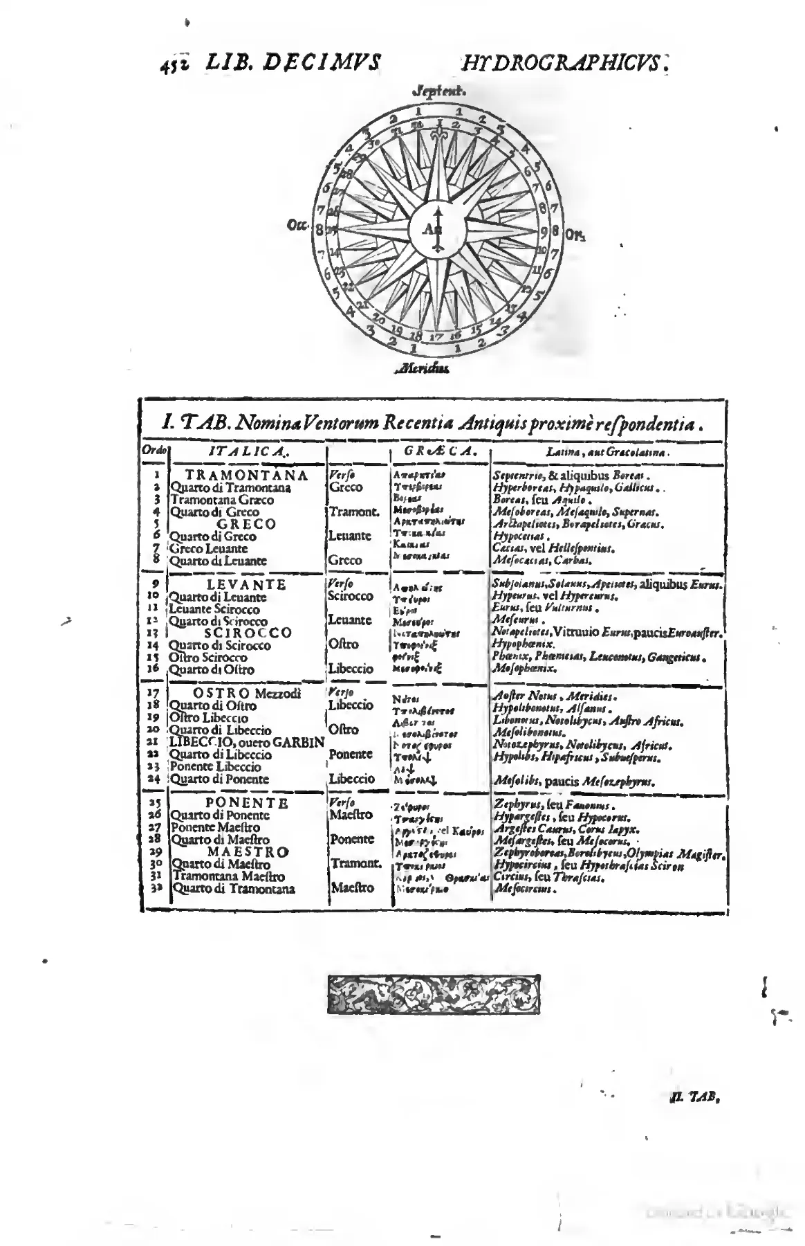
Riccioli's page lets the mariner's compass govern the taxonomy of winds: a numbered thirty-two-point rose, labelled by the cardinal quarters, sits above a ruled table that begins from Italian seamen's names such as TRAMONTANA and aligns them with learned Greek and Latin equivalents. The layout turns navigators' consensus into classroom order, subordinating inherited philological names to the divisions of the nautical instrument. Source ↗.
The loxodromic problems and the limits of the tables
The hydrographic book does not end with description but with drill. Its concluding chapters convert the doctrine of the rhumb into a numbered sequence of problems, each of which is solved not by fresh construction but by entry into tables already computed in the twenty-first chapter, and the verbs that carry the procedure are those of the table-user rather than the geometer: ingredere, quære, descende, è regione, in fronte Tabulæ. The quantities in play are five — the rhumb with its inclination to the meridian, the difference of latitude, the difference of longitude, the Italian miles of meridian intercepted between the two parallels, and the Italian miles run along the rhumb line between those same parallels — and the governing problem states their mutual determination as a closed combinatorial rule, given any two of five, namely the inclination of the rhumb, the difference of latitude, the difference of longitude, the Italian miles of the meridian intercepted between the parallels, and the Italian miles of distance on the rhumb line intercepted between the parallels, to find the remaining three, except in the case when only the miles of distance on the rhumb and the difference of longitude are given, Datis duobus quibuslibet ex quinque, nempe Inclinatione Rhombi, Differentia Latitudinis, Differentia Longitudinis, Milliaribus Italicis Meridiani inter parallelos interceptis, & Milliaribus Italicis distantia in Rhombi linea inter parallelos intercepta, invenire reliqua tria, excepto cau, quando dantur tantummodo Millaria distancia in Rhombo, & Differentia Longitudinis, where the exceptive clause is printed defectively for excepto casu. What matters is that the exception is announced in the statement of the problem itself, before the reader has worked a single case: the apparatus declares the one pairing it cannot resolve at the moment it advertises its own completeness.
The ten præcepta that follow enumerate the admissible pairings one by one, and a single numerical instance is rotated through them so that the same right-angled configuration is seen from four directions. A ship leaves latitude 18° for latitude 21° on the fourth rhumb, whose inclination is 45°; the table yields a difference of longitude of 3°12′ and a run of 254 Italian miles. The arithmetic by which those figures are extracted is the most instructive feature of the chapter, because the table is computed cumulatively from the equator: the entries opposite latitude 21° are 22°8′ of longitude and 1782 miles, from which the entries opposite latitude 18° — 18°56′ and 1528 miles — must be subtracted. Any voyage whatever is thus the difference of two cumulative readings, and one table serves every departure, provided the user remembers to deduct the longitude and the mileage owed to the parallel from which the ship actually sailed. The reversibility is pressed hard: the same 254 miles and 3°12′ are recovered when the inclination and the difference of longitude are given, when the miles of meridian are given and first converted into degrees, and when the distance on the rhumb is given and added to the cumulative figure standing against the departure latitude. Several præcepta are then dismissed as already answered, since given the miles of meridian the difference of latitude is given, so that the case collapses into an earlier one — an economy that reduces an apparently open list of practical questions to a small kernel of operations.
Against this background the treatment of the recalcitrant pairing is exact and unembarrassed. Riccioli states it as a case, not as a failure of the reader, when the difference of longitude is given together with the miles of distance on the rhumb, and this is the case in which the problem is indeterminate, Datur Differentia Longitudinis, & Millaria Distantia in Rhombo, & hic est casus, in quo Problema est indeterminatum, and he supplies the ground of the indeterminacy: the reason is that the difference of longitude on the one side and, on the other, the miles of distance on the rhumb line are common to different rhumbs and to different differences of latitude, so that they do not always correspond to one another in the table, Ratio est, quia Differentia Longitudinis ex vno latere, & alio Millaria Distantia in Rhombi linea sunt communia diuersis Rhombis, & Latitudinum Differentijs, ita vt non semper corresponderent inter se in Tabula. The demonstration is conducted in the first person and in public: seeking 1052 miles he finds a difference of latitude of 11°20′ opposite, but he does not find the required 4°18′ of longitude against it, and the values that would satisfy the one datum push the search toward the seventh rhumb while the other datum holds it at the fifth. Rather than suppress the failed lookup, he prescribes a tolerance, for although the given difference of longitude is not to be had there, nor the given miles, yet there is among the miles a longitude sufficiently near to the given one, under which, by taking the proportional part, you will not stray far from the mark, Nam licet ibi non habeatur data Differentia Longitudinis, nec Millaria data, habetur tamen inter Millaria Longitudo satis vicina data, sub qua sumendo partem proportionalem, non multum aberrabis à scopo; failing that, two variations of longitude are to be investigated and a mean proportional taken between them. The clause non multum aberrabis à scopo is the operational form of the distinction that organizes the whole work: interpolation between adjacent table entries is not demonstration, and it is not offered as such, but it is sufficient for the end in view, and the residual error is acknowledged in the same breath in which the remedy is given.
The great-circle problem is handled by the same tabular economy, and its statement already contains the practical concession that the arc must be sailed as a series of straight courses — given the latitudes of two places and their difference of longitude, to find the angles of position, the shortest distance of the places, and the inclination of the keel to be changed for navigation by the great circle, Datis Latitudinibus duorum locorum, & eorum Longitudinis Differentia; inuenire Angulos Positionis, & Distantiam breuissimam locorum, & Inclinationem Carine mutandam pro nauigatione per circulum maximum. The eighth table of the preceding chapter carries the discretization in its own columns: for a passage from 30° to 50° of north latitude with 26°26′ of longitude between, it returns angles of position of 37°18′ and 125°16′, a distance of 1700 miles by the fourth rhumb against 1690 by the great circle, a total change of keel inclination of 16°26′, and — in the last two columns — the size of each successive alteration, one minute, and the interval after which it is to be made, every 105 miles. The continuous inclination that geometrical rigour would require in every meridian the ship crosses is thus replaced by a staircase of minute adjustments that a shipmaster can actually execute, and the table itself fixes the step. At the same time the numbers quantify the marginality of the gain: ten Italian miles saved over twenty degrees of latitude is the measure of what the more exact doctrine buys.
From the table the chapter turns back to the chart, since the pilot's data are read from it rather than from a book of latitudes — given two places on a sea chart, and their longitude and latitude, to find the rhumb to be chosen for the navigation, Datis duobus locis in Charta Marina, & eorum Longitudine, ac Latitudine, inuenire Rhombum eligendum ad Nauigationem. Here too the worked case ends in an inexact match: the residual 14°33′ is not found under the first rhumb, so the reckoning passes to the second, where 14°14′ stands opposite the departure latitude, and the answer is the second rhumb at an inclination of 22°30′. The problems that follow are almost all disposed of by cross-reference — Hoc coincidit cum Præcepto I. Problematis X., Idem est cum Præcepto IV. — including the frank repetition that the eighteenth problem is the indeterminate one again, to be relieved only by proportional parts or a mean proportional.
The chapter's last two problems leave the single leg behind for the actual shape of a passage. A voyage having been made through several rhumbs, and the miles of the course completed on each having been noted, to find the latitude and longitude of the place the ship has reached, and the rhumb to be chosen for the return to the place from which she set out, Nauigatione facta per plures Rhombos, & notatis Millaribus Itineris in singulis confecti, inuenire Latitudinem, & Longitudinem loci, ad quem Nauis peruenit, ac Rhombum eligendum pro reditu ad locum, vnde solutum est — each leg is resolved into its differences of latitude and longitude, and the partial results are summed with regard to the quarter, north or south, east or west, those toward the same quarter being added and those toward opposite quarters subtracted, the lesser from the greater. The final problem then subjects the whole reckoning to the one thing the mariner can actually observe. If the latitude collected from the estimate agrees with the latitude observed, the estimate was right; if it disagrees, it was erroneous, and the correction is proportional, Quare Differentia inter Latitudinem obseruatam, & collectam, distribuenda est proportionaliter inter singulos Rhombos, seu potius, retentis Rhombis, augenda, aut minuenda sunt Millaria Itineris in eadem proportione, qua se habet Differentia Latitudinis obseruatæ ad collectam; & sic correctis Millaribus, per Problema XIX. inuenietur vera Longitudo loci. The distribution of blame is significant: the courses steered are retained and the distances run are adjusted, on the assumption that the compass is trustworthy where the log and the judgement of way are not. Longitude, never observed, emerges only at the end of the chain, as a quantity computed from mileages that have themselves been rectified by an observation of latitude — which is why the hydrographic book can close upon a rule for emending an estimate rather than upon a demonstration, and why the tables, with their interpolations, their declared indeterminate case, and their staircase of one-minute alterations, are presented as the working substitute for a measurement that cannot be taken at sea.
That series of rules is arithmetical rather than demonstrative in its internal logic: what distinguishes Problem VIII from Problem IX is simply whether the two places lie in latitudes of the same kind or of opposite kinds, the one case calling for subtraction of the lesser longitude and mileage from the greater, the other for the instruction to gather the longitudes into a single sum, Aggrega in vnam summam Longitudinea. The imperative mood is the governing grammar of the whole sequence, and it marks the transformation the treatise performs upon its materials: spherical trigonometry is dissolved into a protocol that a shipmaster can execute without possessing the geometry that justifies it. The series then reverses its own givens — rhumb from latitudes and longitude difference, second latitude from rhumb, distance and first latitude — until it reaches the one case the tables cannot close.
That case is the determination of longitude, and the chapter states its failure with unusual candour. The seaman's predicament is defined by the conditions under which reckoning breaks down, since sailors most need this when, driven by a storm from the rhumb once chosen, they cannot know with certainty by what other rhumbs they have sailed, Cum eo tum maximè indigeant Nautæ quando Tempestate à Rhombo semel electo deturbari, scire certò nequeuit, per quos alios Rhombos nauigarint. What follows is an inventory of defeaters — the unobservable magnetic variation, inconstant winds, currents, a clouded sky — each of which removes one of the inputs the preceding seventeen problems had presupposed as given. The rhetorical effect is to expose the tabular apparatus as conditional upon observational circumstances that the sea does not reliably supply, and the text meets this by naming the problem as a public object of desire rather than a private perplexity: it is precisely that famous point of longitude, already discussed above, for whose discoverer Catholic kings and the Dutch company had promised so many thousands of gold pieces. Naming a Catholic monarchy and a Protestant trading company in the same clause registers the punctum longitudinis as a fiscal and political term of art as much as a mathematical one, and it locates the limit of the author's own tables at the point where the reward of princes begins.
The sea-journal, the chart, and the antiquarian chapters
The response to that limit is not a new instrument but a new discipline of record. The chapter on the sea-journal grades its practitioners in ascending order of diligence — those who note only rhumb, wind, and estimated day's run; those who add wind quality, estimated and observed latitude, longitude difference, and magnetic declination; those who further enter islands, promontories, shoals, the colour of the water, floating weed, currents, fish, and birds — so that the journal becomes a cumulative substitute for the demonstration the tables cannot give. Precisely because its value lies in accumulation, withholding it is construed as an injury, in the complaint already set out above against those who conceal their ephemerides, whether to sell their labour dear to merchants as though indispensable or lest their errors be detected by the more skilful. Two motives are distinguished with some acuity — the pilot's commercial interest in monopolizing a scarce competence, and the practitioner's fear of correction by his betters — and both are subordinated to bonum publicum, the same criterion under which the volume itself is licensed. The specimen journal that follows, opened with the invocation IN NOMINE D. O. M., in the name of God, best and greatest, and entered against the fictive voyage of the ship S. Raphael on 1 April 1645, converts the exhortation into a printed form: columns for rhumb, wind, half-hour glasses, miles, estimated and observed latitude, and magnetic declination, with a note on the three-hour watch rotation. The journal is thus published as a genre with a template, which is the characteristic gesture of the book — not the discovery of a fact but the regularization of a practice.
The chapter on plotting carries this material logic further, and it is here that the treatise is most attentive to the chart as a physical object. The operation is named in Italian and French as well as Latin, divided into a mechanical praxis with dividers and a logistic praxis by the tables, and hedged with a warning about the surface itself: on a hydrographic chart the aforesaid points must not be marked with an indelible sign, lest it be spoiled and the places marked there be obliterated, but with a deletable one, such as red chalk or charcoal, Memineris verò in charta Hydrographica non esse notanda puncta prædicta signo indelebili, ne deturpetur, & obiterentur loca ea co[n]signata, sed delibili, puta lapillo rubro, aut carbonario. The chart is treated as durable and costly equipment whose printed nomenclature must survive repeated use, and the instruction quietly discloses what the preceding problems concealed: that the working instrument of navigation is consumable, defaceable, and shared across voyages. The following sections then set observed against estimated latitude to determine whether the run or the rhumb was at fault, extending the correction to a composite course of four legs, and close with a list of predecessors — Medina, Snellius, Crescenzio, Mersenne, Hérigone, Fournier, Varenius — faulted for brevity or obscurity rather than for error, which situates the chapter's claim to novelty in exposition rather than in doctrine.
Spherical sailing is introduced under a heading that frames it as a question of expediency rather than of geometrical truth, namely to discern whether it be advantageous to set up a navigation by the great circle, Discernere vtrum expediat navigationem instituere per circulum maximum. The six problems that follow, built upon the author's comparative table constructed by the analysis of spherical triangles, culminate not in a recommendation but in the refusal already quoted, that a saving of two Italian miles is not such that it is worth the trouble to depart from the common method of navigating. The communis methodus thereby acquires a presumption in its favour which the shortest path must overcome by a quantified margin, and the argument is reinforced by the observation that great-circle sailing demands more geometry than shipmasters are commonly granted. The reforming programme here declines to reform: the criterion of utility, having been used to displace speculative meteorology and to demand the publication of journals, is turned against the mathematician's own optimum.
The antiquarian chapters that open the third section of the book operate by a different economy of proof, and their most revealing moment is a borrowed confession. Expounding the vexed question whether the three orders of ancient oarsmen, the thranites, zygites and thalamites, Thranitas, Zygitas, & Thalamitas, were ranged lengthwise or vertically, the text sets Lazare de Baïf's four arguments against the vertical arrangement upheld by Scaliger, Snellius, Scheffer and Morisot, and quotes with evident approval Baïf's own frank admission, already set out above, that it is still not clear to him whether his conjecture is true, so that he seems to himself tossed in a shipwreck of opinions from which he cannot emerge by his own effort. The metaphor of a naufragium opinionum is exactly suited to its subject, and the citation does double work: it certifies a scholarly virtue the treatise practises elsewhere on its own account, and it converts an unresolved philological controversy into a demonstration of how conjecture ought to be marked. That the following remark notes how others were led into error notwithstanding the warning gives the borrowing a polemical edge.
The same chapters are where the book's social vocabulary is least guarded. The enumeration of naval offices descends from Duumviri navales through Nauarchus, Magister Navis and Nauclerus to caulkers, coopers and sounders, and ends with the threefold division of oarsmen into volunteers, purchased slaves, and others condemned by judges to the oar, and these are called in Italian forzati, alij damnati a iudicibus ad remigandum, et hi dicuntur Italice Forzæ. The classification is delivered in the same register as the tabulated proportions of masts and yards, the labour of the galley being entered among the ship's specifications rather than among its moral problems.
The chapter on famous vessels then turns a technical treatise briefly into a repository of learned puzzles and imperial commemoration. The Delian ship of Theseus, preserved by continual repair, raises the question of numerical identity under total replacement of matter, which the text resolves by the jurist's ruling that if a ship had been so often repaired that no plank remained the same but all were new, it would nonetheless be judged the same ship, Si nautis adeo sæpe refellisset, vt nulla tabula eadem permaneret, qua non nona fuisse, nihilominus tandem nauum existimari. Legal continuity of title is admitted as an adequate answer to a metaphysical difficulty — a solution consonant with the book's habit of settling disputes by the criterion appropriate to the practice in question. The catalogue closes with the verses decreed for the annual refurbishment of Magellan's surviving vessel, in which the ship speaks: I first encircled the globe with sail-borne courses, led by you, Magellan, through a new strait; I circled it, and am rightly called Victoria: my sails are wings, my prize glory, my battle the Sea, Prima ego velimolis ambini cursibus orbem, Magellano novo, te duce, ducta freto. Ambuii, meritoque vocor Victoria: sunt mi Vela ala, pretium gloria, pugna Mare. The prosopopoeia converts a hull into a monument of priority, and the figure of sails as wings recurs, in a wholly mathematical key, in the instrument that concludes the work.
Book XI: the Onomasticus
The onomastic book opens by restricting itself before it begins. Its inclusion criterion is stated as the first of the Monita: let the reader know that only those places are listed in this onomasticon whose ancient Latin name has for the most part passed into another, later name, Sciat Lector ea tantummodo loca in hoc Onomastico recenleri, quorum antiquum nomen Latium plerumque descuiit in aliud nomen dicerium. The repertory is therefore not a gazetteer of the world but a register of onomastic rupture, which explains both the absence of names that never changed and the presence of many entries not to be found in Ortelius. Because the evidence for such ruptures is chains of corrupted forms — the Ferrarese Caput Eridani degenerating through Co d'Eridano and Codarana to Quadrea — the book must also license a weaker grade of assent than demonstration, and it does so in terms proper to the schools, for so long as mere probability leaves the judgement free to hold an opinion, Quamdiu enim meræ probabilitas opinandi liberum perauitit arbitrium. Probable identification is thus admitted as legitimate scholarly work, provided its status is declared — the same discrimination between demonstrated measure and marked conjecture that governed the loxodromic tables, now applied to names rather than to distances, and followed by a catalogue of authorities and an alphabetical dictionary running from Aballo to Asturum with its abbreviations expounded for the reader's use.
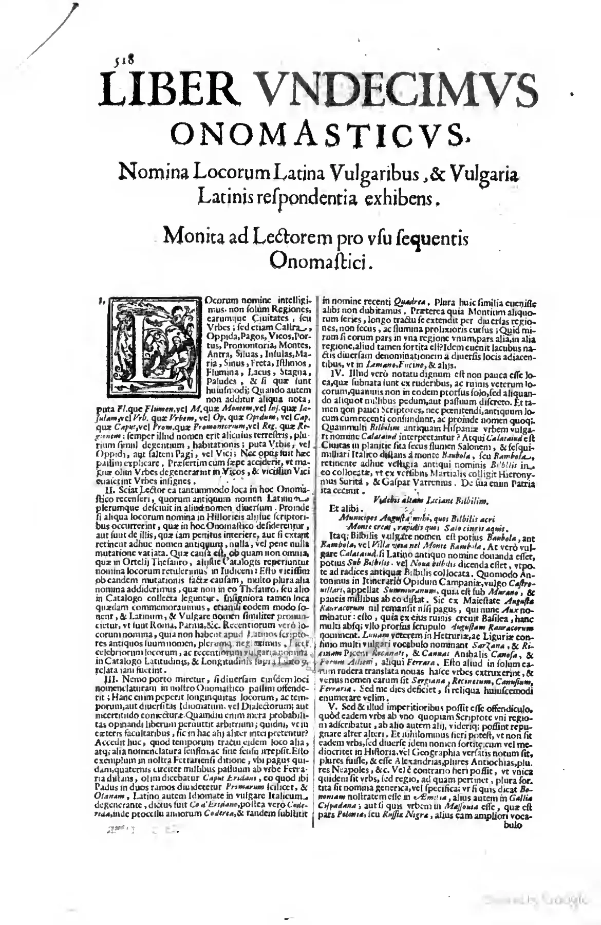
The opening of Book XI, headed LIBER VNDECIMVS ONOMASTICVS, introduces the Monita ad Lectorem beneath a large historiated initial, framing the onomasticon not as a universal gazetteer but as an instrument for tracking places whose ancient Latin names had shifted into later forms. Its numbered cautions make visible the method of managed uncertainty: divergent nomenclature and probable identifications are admitted, but only under rules that mark conjecture as conjecture. Source ↗.
The anatomy of an entry is best seen in the run of the letter A, where the lines are overwhelmingly two- or three-part: vernacular form, Latin equivalent, and a generic-plus-region tag drawn from a fixed stock of abbreviations — opp. for oppidum, vrbis for urbs, fl. for fluuius, and beside them mons, insula, regio, pop. for populi, lacus, sylua, promontorium, portus, arx, castellum, castrum, pagus, comitatus, regnum, mare, sinus, prouincia. Variant forms are routed to a single headword by the instruction Vide, "see", which sends Amabia to Amasia, Amaros to Marmarici, and Ambian to Amiens; and the recurrence of the same place across successive pages under differing vernacular spellings — Amsterdam and Ammosterdam beside Amstelodamum, Auranches beside Abrincæ, Arzila beside Arcila — shows both that the repertory runs in more than one sequence, vernacular to Latin and Latin to vernacular, and that a single toponym may be entered several times over. The divergence of authorities is registered rather than resolved by the ablative alijs, "according to others", as in the line giving Amalfi, Amalphia, otherwise Amelia, a city of Campania, Amalfi, Amalphia, alijs Amelia, vrbis Campaniæ, and by the doubled Latin forms of the entry giving Amaria, Amaris, and according to others Cinaria, an island of the Aegean, Amaria, Amaris, & alijs Cinaria, insula Ægypti; an alternative identification may also be marked by seu, as in Arcadia, or Cyparissia, a city of the Peloponnese, Arcadia, seu Cyparissia, vrbis Peloponnesi.
Antiquarian layering is visible wherever the Latin form is an ancient name distinct from the modern vernacular, and it is made explicit by olim, "formerly", as in the entry giving Albarracín, Lobetum, formerly Turbela, a city of Aragon, Aluarazin, Lobetum, olim Turbelæ, vrbis Aragoniæ. The same operation gives a modern Spanish province its Roman name, Andalusia, Baetica, a region of Spain, Andalucia, Bætica, regio Hispaniæ, and attaches a Roman colonial title to a Swiss village, Aust, Augusta Rauracorum, a village near Basel, Aust, Augusta Rauracorum, pagus prope Basileam; Anduxar is equated with Illiturgis, Azoph with Tanais, Amadan with Ecbatana, Ambrun with Eburodunum, Auch with Augusta Ausciorum, Augsburg with Augusta Vindelicorum, Aosta with Augusta Prætoria of the Salassi. The Ptolemaic nomenclature of Asia is handled in the same way, the Golden Chersonese being identified with Malacca, a region of India, Aurea Chersonesus, Malacca, regio Indiæ, while the Dutch city of the Zuiderzee appears under a vernacular spelling as Ammosterdam, Amstelodamum, a city of Holland, Ammosterdam, Amstelodamum, vrbis Hollandiæ.
Colonial and extra-European toponymy is Latinized on exactly the same footing as European, and the New World is simply given its place in the universal alphabetical order as America, America, the fourth part of the world, America, America, quarta orbis pars, with ethnonym and toponym treated together in the entry for the Amazons, Amazones, peoples of southern America, Amazones, Amazones, pop. America meridionalis. Beside these stand Americani as peoples of America, Andes as mountains of America, Anticosti, Antigua and Anegada as islands of America, Arequipa as a city of Peru with Aymaraes as its peoples and Arica as a town of the same, Amboino as an island of the Indies, Ambora as a city of Japan, Assam as a kingdom of India, Angola as a kingdom of Africa, and a long series of towns tagged to Ethiopia. Ecclesiastical and administrative geography is embedded in the tags themselves — comitatus for a county, regnum for a kingdom, pagus Heluetiæ for a Swiss village, arx Hierosolymæ for the Antonia fortress at Jerusalem.
The transmission of these columns is heavily and systematically corrupted, and the corruption is of kinds that affect interpretation: vrbis stands throughout for urbs; Ægypti evidently stands for Ægæi in the island entries, so that Amorgos, Andros and the Archipelago are all assigned to an Egyptian rather than an Aegean sea; Æthiopiæ recurs as the tag for African interior entries; and the running head is printed variously as LIBER VNDECIMVS ONOMASTICVS, Liber Vniv[er]salis Onomasticus, Liber Vnecimvs Onomasticus, and Liber Vniversalis Onomasticus. The printed page numbers of this stretch run 572–575.
Further into the alphabet the reforming programme of the title ceases to be argued and becomes a page-format. What the reader meets in the stretch running from the close of K into L is not discourse but a two-column repertory whose every line obeys a compressed grammar: vernacular lemma, Latin equivalent or equivalents, an abbreviated genus, and a region in the genitive. The opening entry of the sequence is typical of that economy, giving Kendale, Concangium and Concanginum, a town of England, Kendale, Concangium, & Concanginum, opp. Angliæ. Four elements are doing distinct work. The headword is the form a traveller, a chart, or a relation would supply; the Latin is what learned discourse requires; the abbreviation opp. assigns the object to a class within a taxonomy that runs across these columns through vrb., prou., regio, fl., mons, lacus, palus, prom., inf., and even populi; and the genitive region fixes the object within the descriptive geography of the preceding books. The entry is thus simultaneously a lexical equation and a classificatory act, and the alphabet is the only argument offered for the order in which these acts occur.
The repertory does not pretend that the equation is single-valued. Where authorities diverge, the divergence is printed rather than resolved, by means of the bare ablative alijs, "according to others": so the entry giving Kenili, Vroconium, a town of England, Anconium according to others, Kenili, Vroconium, opp. Angliæ, Anconium alijs. This is a critical apparatus reduced to a single word, and its effect is to convert the gazetteer from a table of identities into a register of competing identifications. The user is handed the dissent without the adjudication; the labour of choosing between Vroconium and Anconium is left where the compiler believes it belongs, with whoever must actually cite the place. The same restraint governs the antiquarian identifications that dominate the Asian and Near Eastern entries. Kerman appears twice in the column, first as Kerman, Carmania, a province of Asia, Kerman, Carmania, prou. Asia, and again, some lines later, as Kerman, Sagartia, Carmania, a region of Asia, Kerman, Sagartia, Carmania, regio Asiæ. The duplication is not a simple redundancy: the second entry imports a further ancient name and silently shifts the generic term from provincia to regio. Two separate sources have evidently been excerpted in turn and both have been allowed to stand, so that the printed column preserves the stratification of its own compilation.
That stratification becomes conspicuous where alphabetization itself severs a single name. The Ottoman toponym for the bridge on the Danube is entered under K-i as Kioupruk, Trajan's Bridge, a place in Serbia, Kioupruk, Pons Traiani, locus Serbiæ, and again, twenty-odd lines further on, under K-u, as Kuppruk and Kiopruk, Trajan's Bridge, otherwise Cinabra, a place in Serbia, Kuppruk & Kiopruk, Pons Traiani, aliæ Cinabra, locus in Seruia. The second entry even absorbs the first headword as a variant of itself, and adds an alternative Latin name absent from the earlier line, while the region wavers between Serbiæ and in Seruia. Here the instability the repertory was built to manage — remoteness of places and times, diversity of idioms and dialects, uncertainty of conjecture — reappears inside the finding-apparatus, because an alphabet keyed to the transliterated vowel of a Turkish word cannot keep one name in one place. The example is doubly instructive: a Roman imperial monument is filed under its contemporary Ottoman designation, which is to say that the living usage of those who travel the region, not the authority of the ancient geographers, supplies the headword, while the Latin column preserves the antiquarian identification as the object of reference rather than as the means of access.
The risk attending so compressed a format is visible two entries apart in the same column, where near-homographs are assigned to referents a thousand miles distant from one another: Kichar, the Cydnus, a river of Cilicia, Kichar, Cydnus, fl. Cilicæ, stands immediately above Kicher, the Tigris, a river of Armenia, Kicher, Tigris, fl. Armeniæ. A single vowel divides the two, and the repertory's grammar supplies no room for the comparison of authorities that would secure either. Such a pair shows exactly what the Onomasticus buys and what it pays: the format guarantees rapid retrieval and a stable Latin form for citation, at the cost of suppressing the evidentiary reasoning that would allow a reader to test the equation. The work's habitual distinction between what is demonstrated and what is conjectured, so explicit in the mathematical and hydrographic books, survives here only as the monosyllable alijs, which is why entries lacking it can look more certain than their sources warrant.
At the far edge of the method lie the names for which no Latin exists to be found. The column registers Kirghesi, Kirghesi, peoples of Great Tartary, Kirghesi, Kirghesi, populi Tartariæ magnæ, where the Latin equivalent is simply the headword repeated, and where the genus is not a settlement or a natural feature at all but a population — the gazetteer quietly widening its category of geographical object to accommodate a nomadic people whose identity is not fixed to a site. The Asian entries show the two available procedures side by side: Lacca, Lacca, a city of India, Lacca, Lacca, vrb. Indiæ, where nothing is done to the form at all, and Lachot, Lachotum, a city of India, Lachot, Lachotum, vrb. Indiæ, where a second-declension ending is affixed and the name is thereby made declinable in a Latin sentence. Neither operation has any warrant in ancient usage; both are justified only by the working maxim of the book, that intelligibility to those who must use the name outranks the purity for which grammarians would contend. The northern entries display the third procedure, translation rather than transliteration, and print both results without preferring either: Lago Bianco, the Bela lake, the White lake, in Muscovy, Lago Bianco, Bela lacus, Albus lacus, in Moscouia. The vernacular sound and the vernacular sense are each rendered into Latin, and the reader is left holding two equally authorized forms for one sheet of water.
The most considerable structural event in this stretch is the moment when the alphabet of proper names is interrupted by an alphabet of generic ones. A ruled heading equates the Italian, the French, and the Latin common noun — lake — as Lago, Lac, Lacus, after which the column ceases to file lakes under their distinguishing element and files them all under the class-word. The logic is a concession to how vernacular toponyms are actually built, as syntagms of generic plus proper, and it makes the repertory usable by a reader who has read Lago di on a chart and does not know whether to seek the entry under G or under C; but it also dissolves the very distinction that makes a name a name, gathering the lakes of Latium, Muscovy, Ethiopia, and Sardinia into a single block whose only shared property is that their describers called them lakes. Within that block the compilation's dependence on divergent charts becomes plainly legible. The Sabatine lake is entered twice under two different vernacular headwords and two different antiquarian regions, once as Lago di Aiguier, the Sabatine lake, in Latium, Lago di Aiguier, Sabatinus lacus, in Latio, and once as Lago di Bracciano, the Sabatine lake, in Etruria, Lago di Bracciano, Sabatinus lacus, in Hetruria. One body of water, one ancient name, two vernaculars, and two incompatible ancient provinces: the contradiction is not concealed but neither is it flagged, and it exposes the condition of the whole repertory, which is that its redundancies are the fossils of the plural sources it declines to harmonize by force.
Finally, the column registers that places are perishable while names are not. Under the Greek liturgical form stands an entry for a Sicilian town that no longer exists, Kyrieleison, Palica, a destroyed town of Sicily, Kyrieleifon, Palica, opp. Siciliæ excitum [reading uncertain]. The genus oppidum is retained, qualified by a participle that cancels it; the entry thus preserves an equation between a modern appellation and an ancient site whose referent is a ruin. It is a small but exact statement of what the Onomasticus is for. The repertory does not describe the surface of the earth; it stabilizes the words by which the earth has been, and continues to be, spoken of, in the knowledge that those words are distributed across languages, centuries, charts, and the fallible conjectures of those who compare them.
The book declares its identity on every recto by a printed running head that reads, Book Eleven, the Onomasticon, LIBER VNDECIMVS ONOMASTICVS. 617, and that standing line, with its display capitals marking each new letter of the alphabet, is the only architecture the book needs. The cumulative claim made by such a form is nevertheless a strong one, and it is continuous with the reforming programme of the title: that the whole inhabited world, ancient and modern, Latin and vernacular, can be reduced to a single collatable name-register in which any form encountered in a chart, a relation of a voyage, or an ancient author can be run down to its referent.
The anatomy of that claim is visible in a single well-formed entry, which gives Kilkenny, the shrine of Canicus, Kilcheumia, a city of Ireland, Kilkenny, Fanum Canici, Kilcheumia, / vb. Hiberniæ. Four operations are performed in one line. The vernacular form stands first, because it is the form a reader will actually have met. The primary Latinization renders the Gaelic element cill by Fanum, the Roman word for a sanctuary or cultic precinct, so that a Christian hagiotoponym is carried into Latin by a term with pagan cultic ancestry — a translation strategy applied across the whole of the enormous Santo / Santa / Sainct / Saint sub-register later in the alphabet, and one that quietly assimilates the sacred topography of the north to the vocabulary of Roman religion. A second, competing Latinization follows, unranked. Only then come the categorial tag and the region. The same standardizing impulse governs the juridical vocabulary: an Irish shire is given as Kerry County, the county of Kerry, in Ireland, Kerry Countie, Kervensis Comitæus, in / Hibernia, where comitatus is made to serve English, Irish, Welsh, and continental divisions alike, rendering heterogeneous early modern administrative forms commensurable by translating them all into one Latin juridical term.
Because the register exists to be used rather than admired, it is built to absorb orthographic instability rather than to legislate it away. The device for this is the cross-reference, as in the bare instruction to see Keureuz, Kerez. Vide Keureuz, which converts what looks like a linear list into a two-way concordance in which variant spellings converge on one identification. This is the practical implementation of the diagnosis offered at the head of the repertory, where divergent nomenclature is traced to distance of places and times, diversity of idioms and dialects, and the uncertainty of conjecture. The Vide device answers the second of those causes; the third is met by a different apparatus, the formula alijs, "according to others," which recurs hundreds of times and registers a disputed ancient identification without settling it. Its effect is at its clearest in the nested lake-catalogue, where Lake Constance or the Bodensee is glossed as the Brigantine, Venetic, or Podamusan lake, of Swabia, de Constance seu Bodenzee, Briganius, / Venicus, seu Podamusus, lacus / Sueuiæ. Three ancient names are laid out for one sheet of water and none is preferred. The method is cumulative rather than critical: the register supplies the reader with the full range of forms under which the referent may be met in the sources, leaving adjudication to whoever has better evidence. Only occasionally does the apparatus name the contending authorities instead of subsuming them, as in the Canary entry giving Palma, one of the Fortunate Isles, called the lesser Junonia by Pliny but Antiola by Ptolemy, Palma Isola Fortunata Palma, alias Iunoma minor Plunio, sed Antiola Prolemæo — a moment in which the silent machinery of alijs becomes explicit philological comparison, and the reader sees that behind every unadjudicated doublet stands a conflict of ancient texts.
Within the alphabetical spine the compiler repeatedly nests thematic sub-registers organized not by the head-word but by its generic element, and these are where the book comes closest to the tabulating habit that governs the hydrographic material. The sea-catalogue is introduced by a heading that is itself a statement of method, four words for one thing across Italian, Spanish, French, and Latin, Marè, Mar, Mer, Mare, with the Latin closing the series as the standard into which the vernaculars resolve. The entries beneath it are governed by a single recurring predicate, as in the Sea of Germany, the German Sea, washing Germany, di Germania, Mare Germanicum, Germaniam alluens. The participle alluens does real conceptual work: seas are defined relationally, by the coast they touch, not by fixed limits — a definition appropriate to a book compiled from charts and pilots' records, where a sea is known by its landfalls. The same sub-register logic admits the newest navigational knowledge on exactly the same footing as the oldest, so that among the straits one finds Hudson's, the Hudsonian Strait, di Hudson. Fretum Hudsonicum, standing in an alphabetical file beside the Bosporus and the Hellespont. No hierarchy of antiquity survives the alphabet; a passage sought within living memory and a classical channel are equally freta, equally entered, equally locatable.
That levelling is the mechanism by which the register absorbs the Atlantic and Pacific worlds. The Latin nomenclature is extended not by inventing a new vocabulary but by declining the old one over new objects, as at New Amsterdam, a city of America in New Belgium, Nouueau Amsterdam, Amsterodamum nouum, vrb. Americæ in nouo Belgio, where a Dutch settlement acquires a Latin name on the pattern of a Roman municipium and is filed within a nouum Belgium that has no classical warrant whatever. The adjective nouus is doing the work that the maxim preferring the grammarians' censure to the people's incomprehension defends: intelligibility is purchased by grammatical extension, and the price is a Latin that the ancients would not recognize. The procedure is carried to its limit where the referent itself is conjectural, as with the Southern Land, Terra Australis, a part of the world, la Terre Australe, Terra Australis, pars / orbis. Here the register's flat form has a consequence its compiler does not mark: a hypothesised continent receives the same categorial tag, pars orbis, as Europe or Asia, and is subdivided in adjacent entries into coasts named by Dutch voyagers. The gazetteer's virtue — that it registers whatever the sources name — becomes, in this instance, an inability to grade the certainty of its own referents, and the careful distinction between demonstration and marked conjecture that governs the nautical books has no place to lodge in a line of three words.
The register is also a catalogue of what has ceased to exist. The tag euersa appears where a classical city has no modern successor on the ground, as at Lagara, Lagaria, a city of Calabria, overthrown, Lagara, Lagaria, vrb. Calabria euersa. Such entries give the book a temporal dimension that a chart cannot have: it records not only where things are but where they were, and the destroyed city is kept in the alphabet precisely because the reader will meet its name in an ancient author and need to place it. The antiquarian layer is thickest where Rome is concerned — within the mountain sub-register the seven hills recur as a fixed grid, as at Monte Cavallo, the Quirinal hill, Acoanius, one of the seven hills of Rome, Cauallo. Qvyrinalis mons. Acoanius, nus / ex septem collibus Romæ — so that the internal topography of one city is treated with the granularity elsewhere reserved for provinces. Roman imperial works enter on the same terms in the north, where the Scots-English name is matched to the Latin earthwork and to the emperor who built it, the Picts' Wall, the Vallum, Hadrian's wall, in Britain, the Picts vuall, Vallum, Hadriani murus, / inBritannia.
Two entries show what the register carries besides location. Classical ethnography is transmitted without qualification as description of a living people in the line giving the Tartars, Maeotae, peoples at the Maeotic marsh in Europe, in European and Asian Scythia, man-eaters, Tartari, Mæna, populi ad Mæotidem paludem in Europa, Scythia Europæ & Asiæ, Antropophagi, where the populi tag, which ordinarily makes a modern territory the heir of an ancient gens, here transfers a Herodotean slur intact, and the equivalence proves to carry evaluative as well as locative content. A confessional category is likewise treated as a geographical one where the Dutch word for Christendom is glossed simply as Europe, the fourth part of the world, Kerstenryck, Europa, pars quârta orbis — the identification of faith with continent stated as a matter of synonymy, while the "fourth part" formula silently concedes the post-Columbian division that the same book's American entries everywhere presuppose. Against these inherited layers stands one wholly contemporary intrusion, the birthplace of the holy father Ignatius, in Guipúzcoa on the borders of Cantabria and Navarre, Loiola, Loyola patria S. P. IGNATII, / Guipecoæ in finibus Canabræ, & / Nauaræ, where a biographical fact is admitted to a purely toponymic list and the modern Basque province is fixed by the ancient names of Cantabria and Navarre. The register thus does in miniature what the whole work does at large: it holds a classical frame steady while filling it with what voyages, missions, and charts have since supplied, and it leaves the seams of that operation visible on the page.
The repertory of names closes in the alphabetical stretch from T to Z, and its final columns display in concentrated form the method that governs the whole: a modern lemma first, then a cluster of ancient and medieval Latin equivalents, then a classificatory abbreviation and a region. The entry for the Habsburg capital gives Vienna, with the forms Ala Flaviana, Flavianum, Juliobona, Vindobona and Vienna, a city of Austria, the metropolis, Vienna, Ala Flaniana, Flauanum, Iuliebona, Vindobona, Vienna, vrb. Austriæ metropolis. What is notable is the refusal to adjudicate. Several of the stacked synonyms are incompatible with one another and at least one is plainly a false identification, yet all are registered side by side, so that the line functions as a record of competing scholarly attributions rather than as a ruling upon them. The same catholicity of intake admits the antiquarian nomenclature of language communities well outside the Romance and Germanic mainstream, as when a Brittonic form is entered and then identified: Troyneuwyth, Londinium, a city of England, Troyneuuyth. Londinium, vrb. Angliæ. Beside such lemmas stand the repertory's two habitual antiquarian tags — the note that a place is excisa or dirutum, destroyed and no longer standing, and the formula vbi … populi, which maps a modern district onto the ancient nation once settled in it. Together these devices stratify the gazetteer: living toponymy, dead sites, and ethnographic substrata occupy the same alphabetical grid, while the geographical reach of the T–Z range extends from Trebizond and the two Tripolis through the Japanese islands and the cities of China to Tucumán, Vera Cruz, Virginia and the Arctic markers of Novaya Zemlya. The list is thus not a nomenclature imposed upon the world but an instrument for comparing the nomenclatures the world has produced.
Book XII: the Crux Geographica
Book XII abandons the alphabet for a single device, and it opens with the definition already set out above, which fixes the instrument's constraints before any operation is taught: two rules joined in the form of a cross and two plates almost imitating the shape of a sigma, laid upon a geographical map ruled with parallel meridians, and competent to represent at any given moment all the varieties of days, nights and hours then occurring throughout the world within the torrid and temperate zones. Three limitations are built into that definition itself. The device is materially trivial — two rules and two curved plates, to be made of metal rather than wood and kept narrow so as to occlude as little of the map as possible. It is not autonomous but parasitic upon a particular kind of printed map, one whose meridians run parallel. And its jurisdiction stops at the polar circles, since in the frigid zones the boundary of day and night is not described by the arms at all. A treatise that begins by publishing the boundaries of its own device is behaving consistently with the work's general habit of grading what it offers.
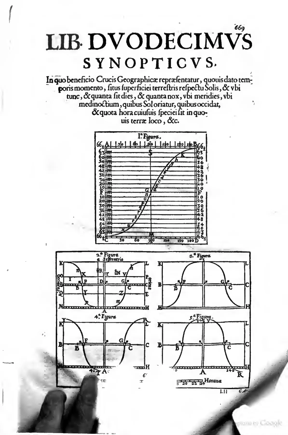
The opening of Book XII, the Synopticus, presents the Crux Geographica as a bounded instrument rather than a universal abstraction: the prose argument promises a world-picture of day, night, noon, midnight, sunrise, sunset, and local hours, while the diagrams below translate that promise into gridded computations and sigma-shaped plate-curves. Setting the latitude-time grid beside configurations of the curved arms on a parallel-meridian map, the page makes visible both the device's construction and the limits governing its use. Source ↗.
The dependence on parallel meridians exacts a price that is stated rather than concealed. Such a projection falsifies the magnitudes of regions, and the recommended arrangement — two copies of the same world map, one cut and recombined so that no portion of the arms ever swings out over blank paper — produces a still stranger artefact, which the reader is instructed to discount: for there is not really in the world a double Europe or a double Africa, and so on; granted that they are assumed by us as doubled, so that no space beneath the arms of the Cross may be found empty of any region, neque enim in Mundo est re vera duplex Europa, aut duplex Africa, &c. esto à nobis geminatæ assumantur, ne quod spatium sub brachus Crucis vacuum ab omni regione inuicatur. The passage is the sharpest methodological moment in the book. Fidelity of area is deliberately surrendered to fidelity of time; the doubled continents are acknowledged as a working fiction of the apparatus, to be suppressed by mind and eye while the hands operate the rules. The user is asked, in other words, to hold two representations at once — the mechanically convenient figure and the true disposition of the globe — and the text supplies the correction rather than allowing the instrument to teach a falsehood.
Upon this foundation the forty-six problems are erected, beginning from the determination of where it is then day and where night, and proceeding through the lengths of days, nights and semidiurnal arcs, the comparison of day-lengths by latitude, the location of noon, midnight, sunrise and sunset, and the conversion of the hour between any two places. The arm-curves are themselves derived from a tabulated body of semidiurnal arcs computed for northern polar altitudes on a stated obliquity of the ecliptic, TABULA Arcuum Semidiurnorum pro Altitudinibus Poli Borealis, supposita obliquitate Eclipticæ gr. 23. 30', so that the plates are a graphical condensation of astronomical computation. The conversion problems must reckon with the coexistence in seventeenth-century Europe and Asia of mutually incompatible civil reckonings — astronomical hours, Italian hours counted from sunset, Babylonian hours counted from sunrise, and the European or French mode — a plurality treated not as confusion to be reformed away but as an ordinary condition of practice requiring a table. The claim made for the resulting facility is the boldest in the book: so you see with what ease you can know the hours of other places of any kind whatever, just as if you were in them and were inspecting or hearing their clocks; and this according to the eight kinds of hours, Ita vides quanta facilitate possis aliorum locorum horas cuiviusus generis nocere perinde. ac si in illis esses, & inspeciseres, vel audires comuni horologia; idque secundum 8. horarum genera. Mediated calculation is here declared functionally equivalent to bodily presence, and the worked examples cultivate exactly that effect: an abstract parallel is immediately populated with the Mexicans, the people of Syene in Egypt and those of Cambay in India, while Rome, Bologna, Nanking and Peking serve as the standing termini of the hour-conversions.
That confidence is nevertheless disciplined where the instrument reaches its competence. Applied to eclipses, the Cross is explicitly reduced from a predictor to a sieve: although parallaxes stand in the way, so that the same solar eclipse cannot be seen everywhere even where it is day, nor of the same magnitude, nor at the same time, we can nevertheless be greatly helped by the Geographical Cross, so as not to undertake the calculation in vain for places, Quamuis parallaxes obstent, quominus eadem Eclipsis Solis, nec vbique etiam vbi est dies, nec tanta, nec eodem tempore cerni possit; possumus tamen per Crucem Geographicam valde iuari ne frulta calculum ineamus pro locis,. The device eliminates impossible localities before the astronomer commits his labour to them; what it cannot do is settle magnitude or moment. The rhetorical peroration of the opening chapter should be read against this restraint rather than apart from it: the figure of the arms as geographical wings, by which a mind shut in one corner of the earth may fly over the whole world, discussed above, is itself carefully hedged — the claim is only that one who called them so would not deviate much from the truth — and the wings carry the mind no further than the temperate and torrid zones, over a map whose continents must be mentally halved.
The demographic appendix and the closing apparatus
The appended demographic essay announces its epistemic grade in its own title, as a treatment of the probable number of human beings inhabiting the surface of the earth, a conjecture attempted with whatever effort, together with corollaries deduced from that number, De Verisimili Hominum Numero superficiem Terre inhabitantium, Coniectura qualicunque conatu attentata, & Corollaria ex hoc numero deducta. Verisimilis and coniectura are doing the same work here that the zonal restriction does in Book XII. The regional excursions that follow are built from heterogeneous materials — Roman census notices whose totals hinge on the reading of a Greek numeral in a corrupt text, parish registers, plague mortalities, missionary relations — and they repeatedly turn quantity into humanist lament, as in the exclamation over the stupendous vicissitude of human mortality, that all Italy is now reduced to that number which Rome alone filled under Augustus, namely to about nine millions of men, III. O stupendam humanæ mortalitatis vicissitudinem? Italiam nunc totam ad cum numerum redactam ESSE, quem sola Roma sub Augusto impleuit, nempe ad 9.circiter Hominum milliones. The commonplace of depopulation is not left as rhetoric but underwritten by plague-by-plague figures for Bologna, Ferrara, Milan, Genoa and Mantua. Where the evidence is foreign, authorities are weighed against one another: China, it is said, is so crowded with people that to one going from one city to another there seem to be perpetual fairs celebrated, and Dudley in the sixth book of the Arcana Maris is cited to the effect that Nanking alone contains two millions of men and Peking as many, China enim tot referta est hominibus, vt eunti ab vna Vrbe ad aliam videantur celebrari perpetuæ Nundinæ. Dudlius lib. 6. de Arcanis Maris p. 37. ait Nanchinom solam duos millions hominum, & totidem Pechinno continere; — a traveller's impression and a naval compendium set beside the provincial table of the imperial census of 1651 taken from Martini's Atlas Sinicus. The sum of a thousand millions is reached by adding such regional conjectures and by allowing generously for the two Americas and the unexplored southern land, and the envoi assigns the whole exercise its status in a pun, already quoted above: the author has played with numbers but has not deluded the world, lusimus conceding the ludic character of the arithmetic, non illusimus denying that avowed play deceives.
The printed back matter continues the work of ordering rather than merely closing it. Lists of the imperial and free cities in the triple form of Latin name, region and vernacular, and of the universities of Europe arranged by realm with their foundation dates, convert juridical and institutional facts into geographical apparatus; two critical catalogues of geographers, ancient and modern, then supply the discipline with a history and a canon, complete with verdicts, as in the judgement that Nicolas Sanson is in the estimation of all easily the first of the geographers of our age, even by the verdict of the Dutch, In omnium Geographorum atatis nostra facilè princeps habens est, ipso etiam Batanorum iudicio — an assessment that concedes the primacy of the Netherlandish trade in maps while awarding the palm to a Frenchman, and which appears a few lines from the compiler's own entry among the moderns. The concluding subject index, keyed to page and column, is itself an argument about what the volume contains, registering technical definitions of the rhumb-line alongside unsettled questions, including the entry that asks who the antipodes are and then lists both their deniers and their defenders, Antipodes qui? 4.1. corum negatores, & assertores. 86. Even at the level of the index the controversy is preserved rather than resolved, which is of a piece with a gazetteer that prints rival names without choosing and an instrument that publishes the zones it cannot serve.
Frequently Asked Questions
What is Riccioli's Geographiae et hydrographiae reformatae libri duodecim?
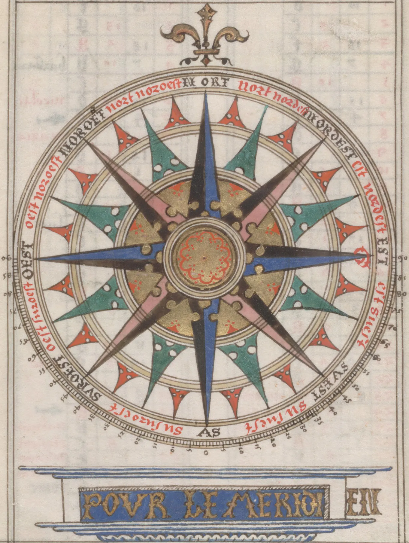
An illuminated compass card from the French portolan tradition makes visible the mariner's thirty-two-part horizon that Riccioli treats as a practical corrective to inherited learned wind systems. Its dense ring of directional points and nautical ornament evokes the world of pilots, charts, and compass practice underlying Book X of the Geographiae et hydrographiae reformatae. Source ↗.
It is an encyclopedic Latin treatise in twelve books, "Twelve Books of Reformed Geography and Hydrography," first printed at Bologna in 1661 by the heirs of Vittorio Benazzi as an illustrated two-column folio of roughly 640 pages, with a revised and enlarged issue of 1672 under Giovanni La Noù. The books run from mathematical geography, metrology, map construction and surveying into Book X on seas, winds, ports, ships and navigation, Book XI's multilingual repertory of place-names, and Book XII's instrument, the Crux Geographica, closing with an appendix on the number of people then alive. "Reformed" here is methodological, not confessional: an inherited discipline corrected by measurement, tabulation and nomenclature.
Who was Giovanni Battista Riccioli?
Giovanni Battista Riccioli (1598–1671) was a Jesuit of Ferrara who spent his mature career in the Society's college at Bologna and is best known to historians of astronomy for the vast Almagestum Novum of 1651. His geography was produced in that Bolognese setting and issued with Jesuit licence and approbation, under the formula Superiorum Permissu, ac Privilegio. He names Francesco Maria Grimaldi as a collaborator, calling one instrument the Grimaldic compass because Grimaldi worked it for years with Riccioli assisting; Grimaldi also demonstrated the height of Mount Athos before the Bolognese professors Giovanni Domenico Cassini and Pietro Mengoli.
Why did Riccioli trust pilots' journals more than the philosophers' books on the winds?
Because, on his account, the seamen's records make nautical motions and storms better known than the meteorologists do, who could scarcely know the regions of sky and earth over which those winds blow. He observes that the natural philosophers do not even agree about the names or divisions of the winds, several having displayed greater subtlety of wit than skill drawn from experience, and that the many recent volumes on the causes and signs of the winds yield little usable fruit. His criterion is what sailors and shipmasters need for safety and speed, which is why he regularizes their usage into quadrilingual wind tables and the thirty-two-point compass rose adopted by the consensus of navigators.
Did Riccioli really try to count the world's population?
Yes. The volume closes with an appendix on the probable number of human beings inhabiting the surface of the earth, a conjecture attempted with whatever effort, concluding that the whole human race then living does not exceed a thousand millions. It proceeds by regional conjecture from census notices, parish registers, plague mortalities, missionary relations and Martino Martini's Chinese figures, remarking that all Italy is now reduced to the nine millions Rome alone once held. Martin Korenjak has identified it as the first systematic attempt presently known to estimate the population of the whole world. Riccioli himself says he played with numbers but did not delude the world.
Is there an English translation of Riccioli's Geographiae et hydrographiae reformatae?
No complete translation into any modern language has been verified in the accessible catalogues and scholarship, and a definitive claim that no partial translation exists would require a separate investigation of the work's translation history. Separately, the Leo edition presents the full transcription together with a complete English translation for the first time; that translation is generated by AI. Leo is an effort to make freely available online, at no cost, English translations of every text printed in Latin in early modern Europe between 1450 and 1750.
This report was generated by an advanced AI assistant that conducted deep research alongside an extensive interpretation of the transcribed original text. Every effort has been made to preserve fidelity to the source and to guard against inaccuracy, but corruption in the text recognition process and model hallucination may nonetheless have entered the text. Treat every claim, quotation, translation, and citation as provisional, and verify each against the original source before relying on or citing it.
Further Reading on Riccioli, Jesuit Science, and Early Modern Navigation
- Peter Dear, "Jesuit Mathematical Science and the Reconstitution of Experience in the Early Seventeenth Century," Studies in History and Philosophy of Science: Dear's account of Jesuit mathematics as a reconstitution of experience through instruments, demonstrations, and disciplined observation supplies the framework readers need for Riccioli's conjunction of geometry, navigation, measurement, and testimony. It is especially useful for the passages where the failure of one class of shipboard instrument motivates the adoption of another, and where the records of navigators are admitted as a distinct evidentiary genre. Few articles have earned their citation count so plainly.
- Mordechai Feingold, ed., Jesuit Science and the Republic of Letters: Seventeenth-Century Perspectives: The essays gathered here place Jesuit mathematical culture within wider regimes of correspondence, publication, patronage, and controversy. For a volume that depends on letters from Kircher, timings from missionaries at Goa and Nagasaki, and the approbations of superiors, this is the contextual apparatus Riccioli himself never printed.
- Christopher M. Graney, Setting Aside All Authority: Giovanni Battista Riccioli and the Science against Copernicus in the Age of Galileo: Graney reconstructs Riccioli's anti-Copernican arguments as serious physical reasoning rather than as obedience dressed up as science, which is exactly the corrective needed before reading his geography. The same habits visible here — exhaustive collation of opposing positions, refusal to overstate a result — recur across the hydrographic books, and the astronomical case is far better documented.
- Martin Korenjak, "Humanist Demography: Giovanni Battista Riccioli on the World Population," Journal of Early Modern Studies: Korenjak provides the most directly relevant modern study of Riccioli's demographic reasoning, treating the population appendix as the first systematic attempt presently known to arrive at an estimate of the entire world population and clarifying its relation to humanist and political-arithmetic traditions. The figure at which the regional excursions arrive is stated as a ceiling rather than a measurement, namely that the sum of the whole human race at this time dwelling upon the face of the earth does not exceed a thousand millions, Atque adeo summa totius humani generis hoc tempore habitantis supra faciem Terræ, non excedere Mille Milliones, and the accompanying disclaimer that the result is a probability reached by conjecture places the appendix within the same economy of marked certainty that governs the hydrographic books.
- Sheila J. Rabin, "Early Modern Jesuit Science: A Historiographical Essay," Journal of Jesuit Studies: Rabin surveys the retreat from treating Jesuit science as an instrument of confessional control and the turn toward its institutional, pedagogical, and empirical practices. The essay pays for itself when one tries to read Riccioli's licences and approbations alongside his insistence that concealing navigational records injures the public good — an argument continuous with, not opposed to, the authorizing apparatus of the volume.
- Paul Slack, "William Petty, The Multiplication of Mankind and Demographic Discourse in Seventeenth-Century England," The English Historical Review: Slack's analysis of seventeenth-century demographic discourse offers the comparative frame for Riccioli's use of conjecture, census criticism, and regional extrapolation. Read beside the appendix, it shows how differently the same arithmetic behaves when it serves a state's fiscal ambitions rather than a Jesuit's cosmological accounting.





.jpg)

